King's Highway
11B (Tri-Town) - www.OntHighways.com
Highway 11B is currently a short
spur route leading into Cobalt from Highway 11 south. Before downloading
Highway 11B extended the entire distance through Cobalt, Haleybury and New
Liskard. In 1998, all but the southern 5.6km of the highway was downloaded
to the local municipalities.
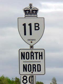
New Style
King's Highway 11B Shield.
Picture courtesy: Patrick Gaudreau
|
|
Southern Terminus: Junction Highway
11 south of Cobalt.
Northern Terminus:
Pre-1997:
Junction Highway 11 north of New Liskeard.
Current:
The southern boundary of the Town of Cobalt.
Length: Pre-1997:
26.10km. Current: 5.6km
Multiplexes: Before downloading,
Highway 11B was co-designated with Highway 65 for 1.9km through New Liskeard.
Highway 65 was rerouted away from that alignment between 1998 and 2003 and
now follows Highway 11Bs former routing for 800m south of the north Highway
11 junction.
Freeway: No
AADT (2002): 1250, for the
entire length of Highway 11B.
Road Info: Coming Soon! |
Communities and Major Intersections along Highway 11B from South to North:
|
Proper Municipality Name |
Community Name |
Distance |
Intersection Road |
|
|
|
0km / 26.1km |
King's Highway 11 |
|
|
Cobalt West Limits |
5.6km / 20.5km |
|
|
Current Northern Terminus of Highway 27 is located
between Eglinton Avenue and Dixon Road. In Toronto, Highway 27 is
known as "Highway 27" |
|
|
|
|
|
|
|
|
|
|
|
|
|
|
|
|
|
|
|
|
|
|
|
|
|
|
|
|
|
|
|
|
|
|
|
|
|
|
|
|
|
|
|
|
|
|
|
|
|
|
|
|
|
|
|
|
|
|
|
|
|
|
|
|
|
|
|
|
|
|
|
|
|
|
|
|
|
|
|
|
|
|
|
|
|
|
|
|
|
|
|
|
|
|
|
|
|
|
|
|
|
|
|
|
|
|
|
|
|
|
|
|
|
|
|
|
|
|
|
|
|
|
|
|
|
|
|
|
|
|
|
|
|
|
|
|
|
|
|
|
|
|
|
|
|
|
|
|
|
|
|
|
|
|
|
|
|
|
|
|
|
|
|
|
|
|
|
|
|
|
|
|
|
|
|
|
|
|
|
|
|
|
|
|
|
|
|
|
|
|
|
|
|
|
|
|
|
|
|
|
|
|
|
|
|
|
|
|
|
|
|
|
|
|
|
|
|
|
|
|
|
|
|
|
Highway 27 ENDS |
Highway 27 - Images
O N T
H I G H W A Y S - Home
Copyright (c) 2004-2010, AsphaltPlanet.ca
AsphaltPlanet@asphaltplanet.ca
Page last updated: February 17th, 2005
Page created: January 4th, 2004