Secondary
Highway 632 - Secondary.OntHighways.com
Highway 632 currently runs south
from Rosseau (at Highway 141) to the Muskoka/Parry Sound Boundary. At the
height of Highway 632's length, it ran south into Muskoka District (along what is
now Muskoka Road 7) and met Highway 118 near Port Carling. The southern
portion of Highway 632 was decommissioned when the District Municipality of
Muskoka was formed in the early 1970s.
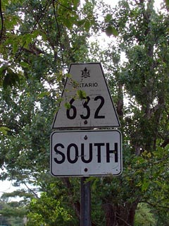
Secondary Highway 632 Shield
|
|
Southern Terminus:
| |
Current: Highway 632 currently ends at
the Muskoka - Parry Sound boundary. |
| |
Historic: Highway 632 ended at Highway
118 just west of Port Carling |
Northern Terminus: Highway 141 junction in Rosseau
Length:
Current: 10.9 km. Historic:
(approximately) 25.6 km
Multiplexes: None
Freeway: No
AADT (2002):
Highest: 980, from Rosseau's west limits to Highway 141;
Lowest: 480, from the south end of Highway 632 to the west limits of
Rosseau.
Road Info: Coming Soon! |
Communities and Intersections along and Highway 632 from South to
North:
|
Proper Municipality Name |
Community Name |
Distance |
Intersecting
Road |
| Muskoka Lakes - Seguin Boundary |
----- |
0 km / 10.9 km |
----- |
| Township of Seguin |
Rosseau |
10.9 km / 0 km |
King's Highway 141 |
|
Highway 632 Ends |
Highway 632 - Images
Secondary.OntHighways.com
- Home
Copyright (c) 2004-2006, Scott Steeves (Webmaster)
webmaster@onthighways.com
Page last updated: January 28th, 2005
Page created: January 28th, 2005