Secondary Highway 670 - www.OntHighways.com

Highway 670 is a short spur highway that runs through the southern part of rural Algoma District, easterly from Highway 638.  Highway 670 is gravel for its entire length and serves local traffic exclusively.


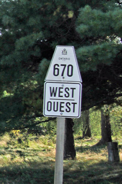
Secondary Highway 670 Shield

  Western Terminus:  Junction Highway 638 north of Bruce Mines.

Eastern Terminus:  Dunn's Valley

Length:  9.5km

Multiplexes:  None

Orientation: East-West

Regions Served: Algoma District

AADT (2008):  80, for the entire length of Highway 670.

Road Info: Highway 670 is unpaved for its entire length.  A sign warning of rough road conditions for the entire length of the highway was posted at either end of the road, though when I travelled the road early in September of 2012, the road had been freshly graded, and was fairly smooth for a gravel road.  The speed limit is posted at 80km/h, but there are several unmarked curves where such a speed would be unsafe.  Highway 670 is fairly tame compared to other Algoma secondary highways, however at times the highway still veers in unexpected directions with little warning.  The Dunn's Valley area is a particularly pretty part of the province, and is worth a visit, particularly in the late summer or early fall.


Highway 670 information:


OntHighways.com  

Detailed Route information available below
Virtual Tour of Highway 670


Communities and Intersections along and Highway 670 from West to East:

Proper Municipality Name Community Name Distance Intersecting Road
District of Algoma ----- 0km / 9.5km Secondary Highway 638
District of Algoma Dunn's Valley 9.5km / 0km Shaw Road
Highway 670 ENDS

<- Highway 668          www.OntHighways.com - Home          Highway 671 ->


Copyright (c) 2004-2012, Scott Steeves (Webmaster)  scott@asphaltplanet.ca

Page last updated:  September 18th, 2012

Page created:  September 18th, 2012