
QUEEN ELIZABETH WAY
1989
| |
Onramp sign for the QEW Toronto located on southbound Cawthra Road in Mississauga. Before the early 1990s, it was prevalent for the MTO to place "QEW" on signs without being incased in a crown. Summer of 1989. |
 |
Construction information sign located on the median between the onramp from soutbound Cawthra Road to the Toronto-bound QEW and the mainline QEW lanes. Summer of 1989. |
| Trapezoid gore exit number sign for Cawthra Road on the Hamilton-bound QEW in Mississauga. Summer 1989. |  |
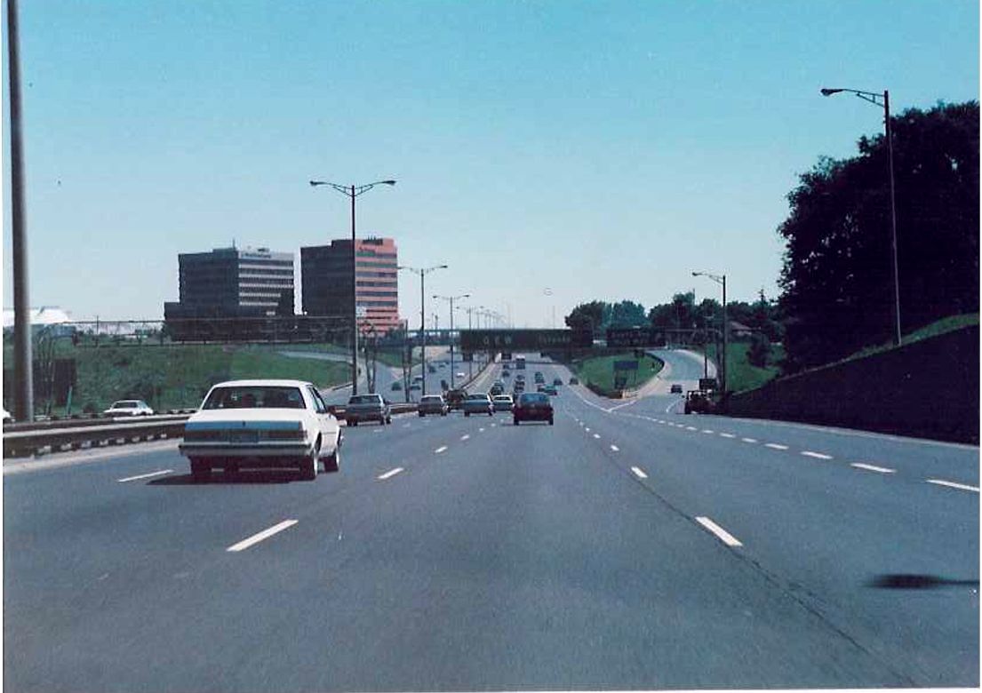
| Overhead gantry at Cawthra Road along the Hamilton-bound QEW in Mississauga in the Summer of 1989. Highway 10 was downloaded to the City of Mississauga in 1998. |  |
 |
Partial view of the pedestrian overpass located between Dixie Road and Cawthra Road on the Toronto-bound QEW. Summer of 1989. |
| Two shots of looking west along the QEW towards Hamilton from the pedestrian overpass in Mississauga. Left shot: Summer of 1981. Right shot: Summer of 1989. Notice the new sound barrier in the newer picture. |   |
 |
Looking towards the Dixie Road overpass on the Toronto-bound QEW in Mississauga. Summer of 1989. |
| Facing west along the Hamilton-bound lanes of the Q.E.W. towards the Dixie Road overpass in Mississauga. Summer of 1989. |  |
| Gore sign on the ramp from Hamilton-bound Q.E.W. to Dixie Road in Mississauga. Summer 1989. |  |
 |
Facing Toronto-bound along the QEW towards the Evans Avenue/West Mall interchange, near the Etobicoke/Mississauga line. Today, this is a two lane exit, although at least in 1989 this exit featured signage (something absent from EXIT 138 on the QEW since the late 1990s). Summer of 1989. |
Municipality of Metropolitan Toronto
 |
Facing Toronto-bound along the QEW at the Etobicoke Creek Bridge. Ramp from Toronto-bound QEW to West Mall and Evans Avenue visible in the background. Summer of 1989. |
| Looking Hamilton-bound along the QEW in Etobicoke at the Evans Avenue overpass. Summer of 1989. |  |
| Looking west along the terminus of the Highway 427 offramp to the Hamilton-bound QEW in Etobicoke. Summer 1989. |  |
 |
2 kilometre advance signage located at the Highway 427 interchange indicating the upcoming exit for the collector lanes on the Toronto-bound QEW. A very similar sign exists in this location to this date. Summer of 1989. |
 |
Partial view of the large flyover ramp from southbound Highway 427 to the Toronto-bound QEW, from the Toronto-bound lanes of the QEW in Etobicoke. Summer of 1989. |
| Advance signage for the 427 along the Hamilton-bound QEW in Etobicoke in the Summer of 1989. Interestingly, no mention of Pearson International airport. |  |
 |
Overhead gantry located on the Torontobound QEW in Etobicoke at the beginning of a 4 kilometre collector/distributor segment. Kipling Avenue overpass in the background. Summer of 1989. |
 |
Partial view of the Kipling Avenue overpass from the Toronto-bound QEW in Etobicoke. Summer of 1989. |
 |
Toronto-bound QEW between Kipling Avenue and Islington Avenue in Etobicoke. Between Kiping Avenue and Royal York Road there exists a short collector/distributor system to accomodate the closely spaced interchanges. Summer of 1989. |
 |
Toronto-bound QEW where the short segment of collector lanes ends, just west of the Royal York Road overpass. Summer of 1989. |
  |
Sign along the Toronto-bound QEW, warning of the impending end of the QEW at Highway 2. Summer of 1989. |
  |
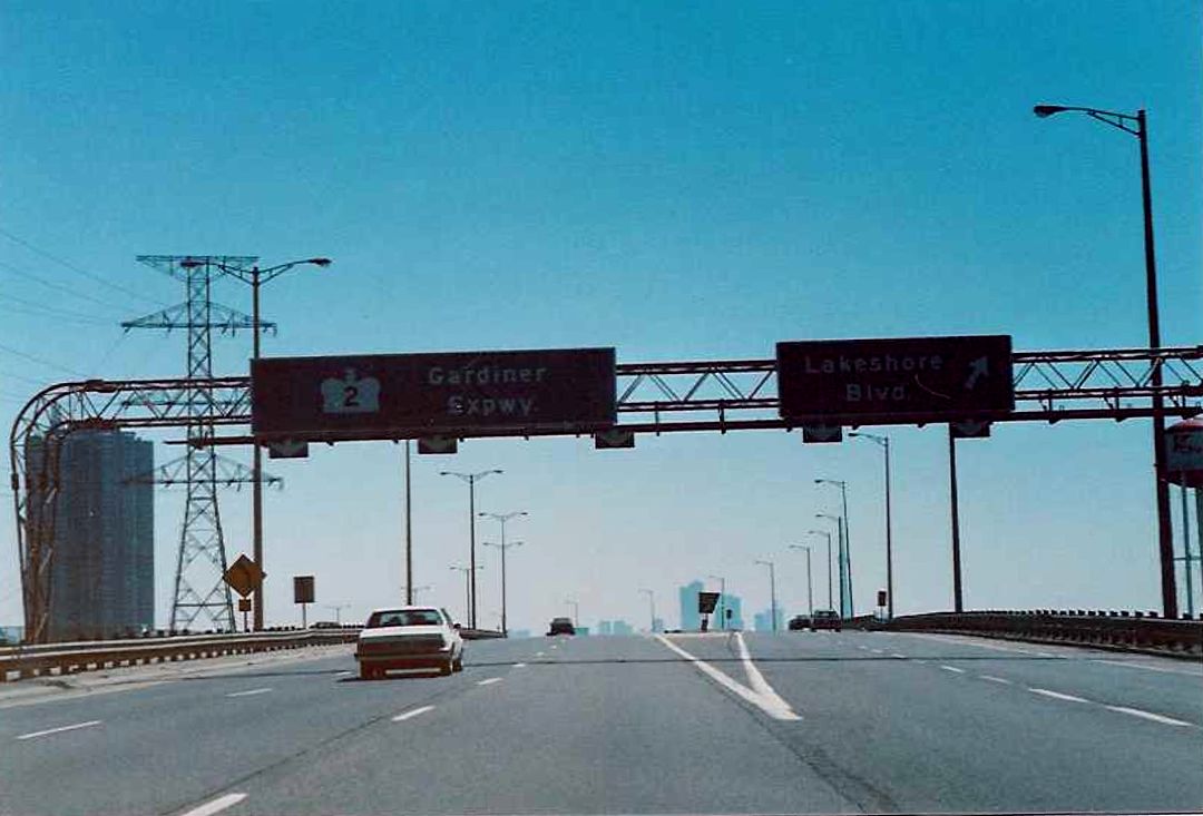
Diagram sign located about 1 kilometre west of the end of the QEW at Highway 2. Before the downloading of 1997/98, Highway 2 was routed along the Gardiner Expressway. Despite Highway 2 being decommissioned, sometime between 1997 and 2000 the signage on the Toronto-bound QEW was replaced to show Highway 2 routed along Lake Shore Blvd, about the same time some city erected Highway 2 junction squares began popping up on Lake Shore Blvd between the Humber Bay and Spadina Ave. My only theory is that for short time after downloading the new City of Toronto toyed with the idea of keeping a municipally maintained highway system. Summer of 1989. |
 |
Toronto-bound QEW approaching the Grand Avenue overpass. Ramp from Toronto-bound QEW to Park Lawn Road pictured to the right. Summer of 1989. |
| Start of the QEW in Toronto at the Humber river bridge. Highway 2 departs with the ramp to the right along Lake Shore Blvd. Summer of 1989. |  |
 |
End of the QEW in Toronto at Highway 2/Gardiner Expressway. At this interchange, the Highway 2 designation transfered from Lake Shore Boulevard to the Gardiner Expressway. Summer of 1989. |
 |
Transition from the Toronto-bound QEW to Highway 2/Gardiner Expressway in Toronto. On the right is the ramp from the Toronto-bound QEW to Lake Shore Blvd. The Toronto skyline is in the background across from the Humber Bay. Summer of 1989. |
 |
Looking east along Highway 2/Gardiner Expressway towards downtown Toronto from the Humber River Bridge. Summer of 1989. |