AsphaltPlanet.ca > OntHighways > Highway 3 > Images
< Hwy 2A    Hwy 3B >

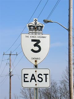
King's Highway 3 - www.OntHighways.com

Before several sections of Highway 3 were downloaded, the Highway 3 designation extended from Sandwich Street at the Ambassador Bridge in Windsor easterly to the QEW at the Peace Bridge in Fort Erie.  This is notable, as no other Ontario highway has had the distinction to have both of its termini at international crossings.  In 1997 and 1998 several sections of Highway 3 were decommissioned leaving three discrete sections of provincially maintained highway today.  These sections now run from Sandwich Street in Windsor easterly to Highway 77 at Leamington; from Highway 4 at Talbotville to Townline Road just west of Port Colborne; and from Highway 140 to Rose Hill Road just west of Fort Erie.  The decommissioned portions of Highway 3 have since been designated by the counties that now maintain the route.  From west to east, the county roads that fill in the discontinuous segments of Highway 3 are: Essex Road 33, Essex Road 34, Chatham-Kent Road 3, Elgin Road 3, and Niagara Road 3.


Old Style King's Highway 3 Shield

  Western Terminus:  At Sandwich Street in downtown Windsor

Eastern Terminus:  Pre-1997:  At the QEW interchange in Fort Erie.

                                      Current: Rose Hill Road just to the west of Fort Erie


Discontinuity (since 1998):  Highway 3 is now discontinuous in two places.  Most notably, all of Highway 3 was downloaded between Highway 77 at Leamington to Highway 4 at Talbotville.  Highway 3 is also discontinuous in Port Colborne as the connecting link has been repealed by the MTO.  Fortunately within Port Colborne there are sporadic signs directing through traffic through the discontinuity.

Length:  Pre-1997: 411.0km.  Current: 115.7 km.

Multiplexes:  None

Freeway:  Highway 3 is a super-2 expressway through St. Thomas

AADT (2002):  Highest:  29,100, from Howard Avenue easterly to Highway 401 in Windsor;

                             Lowest:  2,750, from First Avenue easterly to Centennial Street on the St Thomas Expressway.

Road info:  Highway 3 is generally in fairly good condition.  The western segment of the route is in excellent condition but is quite congested.  The central and longest segment has the most variance in condition but is in for the most part, good or fair shape.  The eastern segment is once again all in good condition.  The downloaded portion between Leamington and St. Thomas is at times fairly rough, but is for the most part quite lightly traveled.  Highway 3 has a rural posted speed limit of 80km/h.


Highway 3 information:


OntHighways.com  

Detailed Route information available below
Virtual Tour of Highway 3


TheKingsHighway.ca   History of Highway 3
Photographic History of Highway 3

VintageKingsHighways.com   Early 1990s Vintage Highway 3 photos

Communities and Major Intersections located along Highway 3 between Windsor and Leamington from West to East:

Proper Municipality Name

Community Name Distance

Major Intersection

City of Windsor Windsor (0km) / (411.0km) Sandwich Street
City of Windsor Windsor --- Wyandotte Street
City of Windsor Windsor --- Tecumseh Road
City of Windsor Windsor (4.4km) / (406.6km) E. C. Row Expressway (Formerly Highway 7087) - To Highways 2 and 18
Windsor - LaSalle Boundary Windsor South Limits (6.7km) / 404.3km) Todd Lane & Cabana Road
Windsor - LaSalle Boundary ----- --- Huron Church Line (Essex Road 7)
Windsor - LaSalle - Tecumseh Boundary ----- (10.3km) / (400.7km) Howard Road (Essex Road 9)
Windsor - Tecumseh Boundary ----- (11.2km) / (399.8km) King's Highway 401
Town of Tecumseh ----- (13.4km) / (397.6km) Walker Road (Essex Road 11)
Town of Tecumseh Oldcastle --- -----
Town of Tecumseh (Maidstone By-pass) (18.4km) / (392.6km) Talbot Road (Essex Road 34)
Tecumseh - Lakeshore Boundary (Maidstone By-pass) (21.2km) / (389.8km) Essex Road 19
Lakeshore - Essex Boundary (Essex By-pass) (24.3km) / (386.7km) Essex Road 8
Essex - Kingsville Boundary (Essex By-pass) (28.1km) / (382.9km) Essex Road 23
Town of Kingsville (Cottam By-pass) (34.3km) / (367.7km) Essex Road 27
Town of Kingsville ----- (37.3km) / (373.7km) Division Road (Essex Road 29)
Town of Kingsville ----- (40.6km) / (370.4km) Essex Road 18
Town of Kingsville (Ruthven By-pass) (43.9km) / (367.1km) Essex Road 34
Kingsville - Leamington Boundary ----- (---) / (---) Albuna Townline Road (Essex Road 31)
Municipality of Leamington (Leamington Bypass) (---) / (---) King's Highway 77 / Erie Street

Detailed Route information for the remainder of Highway 3 Coming Soon!


<- Highway 2A          www.OntHighways.com - Home          Highway 3B ->


Copyright (c) 2004-2010, AsphaltPlanet.ca  AsphaltPlanet@asphaltplanet.ca

Page last updated:  July 13th, 2006

Page created:  April 21st, 2004