|
Proper Municipality Name |
Community Name |
Distance |
Intersection Name |
| Municipality of Killarney |
---- |
0km / 145.0km |
King's Highway 69 |
| Killarney - French River Boundary |
Rutter |
--- |
----- |
| Municipality of French River |
Alban |
--- |
----- |
| Municipality of French River |
----- |
5.1km / 139.9km |
Secondary Highway 607 |
| Municipality of French River |
Jamot |
--- |
----- |
| Municipality of French River |
Ouellette |
--- |
----- |
| Municipality of French River |
----- |
18.3km / 126.7km |
Secondary Highway 528 |
|
In Noelville (Christmas Town):
NB: Turn Right at the four corners of Noelville (junction Highway
535). SB: At the stop sign in Noelville turn left |
| Municipality of French River |
Noelville |
21.5km / 123.4km |
Secondary Highway 535 |
| Municipality of French River |
Chartrand Corner |
--- |
----- |
| Municipality of French River |
Monetville |
--- |
----- |
| French River - West Nipissing Boundary |
North Monetville |
--- |
----- |
| Municipality of French River |
Sucker Creek Landing |
--- |
----- |
| Municipality of West Nipissing |
Notre Dame du Lac |
--- |
----- |
| Municipality of West Nipissing |
Lavigne |
--- |
----- |
| Municipality of West Nipissing |
Verner |
--- |
Old Highway 17 Road |
|
At Highway 17(west): NB: Turn
Right towards Sturgeon Falls. SB: Turn left towards Noelville. |
| Municipality of West Nipissing |
Verner |
72.0km / 73.0km |
King's Highway 17-West |
| Municipality of West Nipissing |
----- |
--- |
Levac Road & Drive-In Road |
|
In Sturgeon Falls: NB: Turn
left towards Field from Highway 17. SB: Turn Right on Highway 17
towards Sudbury and Vernor. |
| Municipality of West Nipissing |
Sturgeon Falls |
87.7km / 57.3km |
King's Highway 17-East |
|
At Cache Bay Road in Surgeon
Falls Highway 64 has a small jog. NB: Turn Right then Quickly
turn left on Albert Street. SB: Turn Right then quickly turn Left on
Imperial Street |
| Municipality of West Nipissing |
Sturgeon Falls |
--- |
Cache Bay Road |
| Municipality of West Nipissing |
----- |
109.8km / 35.2km |
Secondary Highway 575 |
| Municipality of West Nipissing |
Field |
110.4km / 34.6km |
Secondary Highway 539 |
| Municipality of Temagami |
Marten River |
145.0km / 0km |
King's Highway 11 |
|
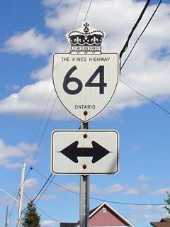
Highway 64 ENDS |
