|
Proper Municipality Name |
Community Name |
Distance |
Intersecting Road |
|
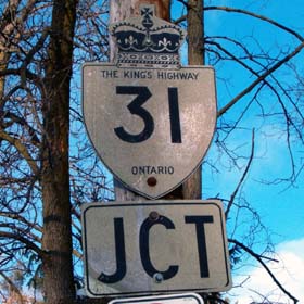
In Sormont, Dundas & Glengarry
County Highway 31 has been renamed to Sormont, Dundas & Glengarry Road 31 |
| Township of South Dundas |
Morrisburg |
0 km / 73.8 km |
Highway 2 (Stormont, Dundas &
Glengarry Road 2) & Lakeshore Drive (Stormont,
Dundas & Glengarry Road 4) |
| Township of South Dundas |
----- |
2.1 km / 71.7 km |
King's Highway 401 (Autoroute Macdonald -
Cartier Freeway) |
| Township of South Dundas |
Glen Becker |
4.4 km / 69.4 km |
Glen Becker Road (S. D. & G. Road 28) |
| Township of South Dundas |
Williamsburg |
9.5 km / 64.3 km |
S. D. & G. Road 18 |
| Township of South Dundas |
The Sixth |
13.2 km / 60.6 km |
S. D. & G. Road 7 |
| South Dundas - North Dundas Boundary |
Winchester Springs |
17.2 km / 56.6 km |
Oak Valley Road (S. D. & G. Road 5) |
| Township of North Dundas |
----- |
23.0 km / 50.8 km |
Highway 43-East (S. D & G. Road 43) & S. D. & G.
Road 38. |
| Township of North Dundas |
----- |
--- |
S. D. & G. Road 38 |
| Township of North Dundas |
----- |
26.8 km / 47.0 km |
Highway 43-West (S. D. & G. Road 43) & S.
D. & G. Road 3. ( |
| Township of North Dundas |
----- |
32.4 km / 41.4 km |
Moorewood Road (S. D. & G.
Road 13) |
|
North of Belmeade Road (Dundas -
Ottawa Boundary) Highway 31 is known as Ottawa Road 31 |
| City of Ottawa |
Vernon |
--- |
----- |
| City of Ottawa |
----- |
40.2 km / 33.6 km |
Marvelville Road (Ottawa Road 4) |
| City of Ottawa |
Spring Hill |
--- |
----- |
| City of Ottawa |
----- |
46.3 km / 27.5 km |
Snake Island Road (Ottawa Road 6) |
| City of Ottawa |
South Gloucester |
55.0 km / 18.8 km |
Mitch Owens Road (Ottawa Road 8) |
| City of Ottawa |
Leitrim |
61.1 km / 12.7 km |
Leitrim Road |
| City of Ottawa |
--- |
63.5 km / 10.3 km |
Ottawa Road 24 |
| City of Ottawa |
Blossom Park |
--- |
Hunt Club Road (Ottawa Road 32) |
| City of Ottawa |
Ottawa |
68.5 km / 5.3 km |
Walkley Road |
|
Turn Left heading north on Heron
Street, heading south turn right on Bank Street |
| City of Ottawa |
Ottawa |
--- |
Heron Street East & Bank Street North |
|
NB: take the ramp to
Bronson Street for Highway 31' SB: Take the ramp for both 31 and 16
and turn left at the end of the ramp |
| City of Ottawa |
Ottawa |
70.8 km / 3.0 km |
Bronson Avenue (Highway 16-South).
(Multiples with 16 starts). |
| City of Ottawa |
Ottawa |
--- |
Highway 17B-West (Carling Avenue). |
| City of Ottawa |
Ottawa |
--- |
Highway 17B-East *EB* (Chamberlain Avenue) |
| City of Ottawa |
Ottawa |
--- |
King's Highway 417 (Queensway) |
| City of Ottawa |
Ottawa |
73.8 km / 0 km |
Highway 17B-East *WB* |
|
Highway 31 ENDS |