Secondary
Highway 550 - www.OntHighways.com
Highway 550 is a short secondary
highway that leads west from Highway 17 in Sault Ste Marie. It heads
through Sault Ste Marie, west to Highway 565, the highway serving the Soo's
airport, to Gros Cap, at the bottom of Lake Superior.
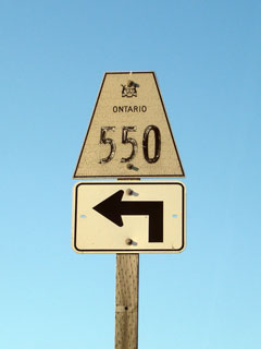
Secondary Highway 550 Shield
|
|
Western Terminus:
Gros Cap
Eastern Terminus:
Junction Highway 17 and 17B in Sault Ste. Marie
Length: 20.6km
Multiplexes: None
Orientation: East-West
Regions Served: Algoma District
AADT (2002):
Highest: 3,500, from Highway 565 easterly to Sault Ste. Marie;
Lowest: 1,550, from Gros Cap easterly to Highway 565.
Road Info: Not available. |
|
Highway 550 information: |
|
|
OntHighways.com |
|
Detailed Route information available
below
Virtual Tour of Highway
550 |
|
Communities and Intersections along and Highway 560 from West to East:
|
Proper
Municipality Name |
Community Name |
Distance |
Intersecting
Road |
| Township of Prince |
Gros Cap |
0km / 20.6km |
----- |
| Township of Prince |
----- |
3.6km / 17.0km |
Gros Cap Road |
| Township of Prince |
----- |
5.0km / 15.6km |
Prince Road |
| Township of Prince |
----- |
7.7km / 12.9km |
Secondary Highway 565 |
| Prince - Sault Ste. Marie Boundary |
Sault Ste. Marie West Limits |
9.3km / 11.3km |
----- |
| City of Sault Ste. Marie |
Sault Ste. Marie |
17.0km / 3.6km |
Highway 550B (Korah Road) |
| City of Sault Ste. Marie |
Sault Ste. Marie |
20.6km / 0km |
King's Highway 17/ King's Highway 17B |
|
Highway 550 Ends |
<- Highway 549
www.OntHighways.com - Home
Highway 551 ->
Copyright (c) 2004-2007, Scott Steeves (Webmaster)
webmaster@onthighways.com
Page last updated: March 6th, 2008
Page created: March 6th, 2008