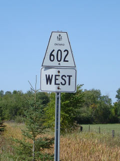
Secondary
Highway 602 - www.OntHighways.com
Highway 602 is the part of the
original colonizational road between Fort Frances and Rainy River. The
highway follows the Rainy River (which is coincidentally, the Canada-USA
border), generally within one kilometre of the river for the highways entire
length. 602 serves primarily local traffic, as through traffic would speed
along the much more direct Highway 11/71 to the north.
Secondary Highway 602 Shield
|
|
Western Terminus: Junction Highway 11/71
in Fort Frances Eastern Terminus: Junction Highway 11/71
in Emo
Length: 47.1km
Multiplexes: None
Orientation: East-West
Regions Served: Rainy River District
AADT (2002):
90, for the entire length of Highway 602.
Road Info: Highway 602 is in very
good condition for the highways entire length. The highway is surfaced
in tar and chip and surprisingly does not have a painted centre line.
Aside from the odd sharp curve, Highway 602 has good geometry and has a
posted 80km/h speed limit. |
|
Highway 602 information: |
|
|
OntHighways.com |
|
Detailed Route information available
below
Virtual Tour of Highway
602 (Coming Soon!) |
|
Communities and Intersections along and Highway 602 from West to East:
|
Proper
Municipality Name |
Community Name |
Distance |
Intersecting
Road |
| Township of Emo |
Emo |
0km / 47.1km |
King's Highway 11/71 |
| Township of Emo |
----- |
12.4km / 34.7km |
Aylsworth Road #2 |
| Township of La Vallee |
----- |
22.2km / 24.9km |
Secondary Highway 613 |
| Townhip of Alberton |
----- |
34.7km / 24.9km |
Secondary Highway 611 |
| Alberton - Fort Frances Boundary |
Fort Frances West Limits |
44.6km / 2.5km |
Boundary Road |
| Town of Fort Frances |
Fort Frances |
47.1km / 0 km |
King's Highway 11/71 (King's Highway) |
|
Highway 602 ENDS |
<- Highway 601
www.OntHighways.com - Home
Highway 603 ->
Copyright (c) 2004-2007, Scott Steeves (Webmaster)
webmaster@onthighways.com
Page last updated: September 26h, 2007
Page created: September 26h, 2007