Secondary Highway
615 -
O N T H I G H W A Y S
Highway 615 is a short highway that
connects Burditt Lake and Off Lake Corner to Highway 71 north of Emo.
Interestingly, part of Highway 615 was at one point part of the King's Highway
network. Highway 70A ran from Off Lake Corner westerly to the current
Highway 71 junction before Highway 70 was more logically realigned in the early
1950s to the
current Highway 71 alignment. Highway 615 was not
affected by the highway downloading programs of the late 1990s.
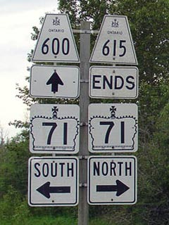
Highway 615 ends at the Highway 71/600 junction
|
|
Southern Terminus: Junction Highway 71&
600 in the District of Rainy River.
Northern Terminus: At the Government dock at Clearwater Lake.
Length: 21.5 km
Multiplexes: None
Freeway: No
AADT (2002):
Highest: 190, from Off Lake Corner to Clearwater Lake;
Lowest: 130, from Highway 71&600 to Off Lake Corner.
Road Info: Excluding a small
section near Highway 71, I have yet to travel on Highway 615, however,
according to area maps, Highway 615 is paved for its entire length.
More detailed information coming soon! |
Communities and Intersections along and Highway 615 from South to
North:
|
Proper
Municipality Name |
Community Name |
Distance |
Intersecting
Road |
| Township of Chapple |
----- |
0 km / 21.5 km |
King's Highway 71 &
Secondary Highway 600 |
|
At Off Lake Road: NB: Turn
Left towards Off Lake. SB: Turn Right towards Highway 71. |
| District of Rainy River |
Off Lake Corner |
--- |
Off Lake Road |
| District of Rainy River |
Burditt Lake |
21.5 km / 0 km |
(Clearwater Lake) |
|
Highway 615 ENDS |
Highway 615 - Images
O N T
H I G H W A Y S - Home
Copyright (c) 2004-2007, Scott Steeves (Webmaster)
webmaster@onthighways.com
Page last updated: April 23rd, 2005
Page created: April 23rd, 2005