Secondary
Highway 627 - www.OntHighways.com
Highway 627 runs along the western
side of the Pic River southerly from Highway 17 terminating at Pukaskwa National
Park.
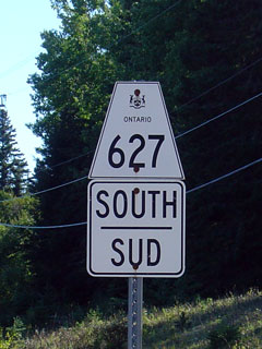
Secondary Highway 627 Shield
|
|
Southern Terminus:
Pic River
Northern Terminus: Junction Highway 17 east of Marathon
Length: 12.2km
Multiplexes: None
Orientation: North-South
Regions
Served: Thunder Bay District
AADT (1994):
600, for the entire length of Highway 627
Road Info: Not available |
Communities and Intersections along and Highway 627 from South to North:
|
Proper
Municipality Name |
Community Name |
Distance |
Intersecting
Road |
| District of Thunder Bay |
Pic River |
0km / 12.2km |
----- |
| District of Thunder Bay |
Heron Bay |
--- |
----- |
| District of Thunder Bay |
----- |
12.2km / 0km |
King's Highway 17 |
|
Highway 627 ENDS |
<- Highway 626
www.OntHighways.com - Home
Highway 628 ->
Copyright (c) 2004-2016, Scott Steeves (Webmaster)
scott@asphaltplanet.ca
Page last updated: January 2nd, 2016
Page created: March 6th, 2008