|
|
|
|
|
|
South-
Bound
|
|
Los Angeles County
City of Los Angeles
|
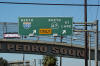
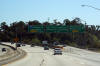
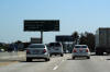
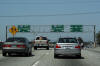
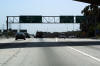
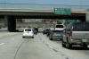
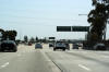
Northbound signage along Gaffey Street at the
southern terminus of Interstate 110. |
 |
|
Photographed by: AsphaltPlanet.ca |
Date: 4/07/2010 |
High-res
|
|
Los Angeles County
City of Los Angeles
|
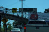
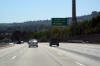
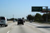
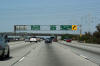
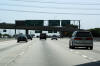
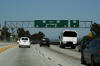
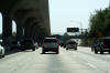
Southbound signage at the end of the freeway at
the Gaffey Street traffic signal. Oddly I-110 is indicated as
progressing southerly along Gaffey Street. About a mile of Gaffey
Street, from this intersection southerly is indeed maintained by Caltrans
as State Highway 101, however
since Gaffey is an at-grade arterial, it could hardly be considered an interstate highway. |
 |
|
Photographed by: AsphaltPlanet.ca |
Date: 4/07/2010 |
High-res |
|
Los Angeles County
City of Los Angeles
|
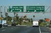
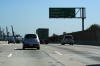
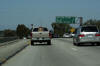
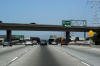
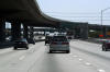
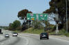
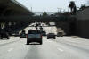
Exit signage heading northbound along the Harbor
Freeway for Highway 47 and the Vincent Thomas Bridge. The Vincent
Thomas Bridge was made famous in the movie 'Gone in Sixty Second's' for
a harrowing chase scene that concluded with Nicolas Cage jumping a 1967 Shelby
Mustang over an accident scene on the bridge. |
 |
|
Photographed by: AsphaltPlanet.ca |
Date: 4/07/2010 |
High-res
|
|
Los Angeles County
City of Los Angeles
|
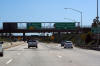
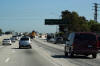
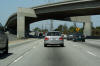
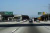
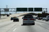
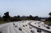
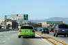
Southbound signage for Highway 47 along I-110.
Highway 47 is a short freeway that links the Harbor Freeway to Terminal
Island. Terminal Island is home to both the Port of Los Angeles,
and the Port of Long Beach. |
 |
|
Photographed by: AsphaltPlanet.ca |
Date: 4/07/2010 |
High-res |
|
Los Angeles County
City of Los Angeles
|
Advanced signage for Highway 47 signed at the
Channel Street / Pacific Avenue interchange. |
 |
|
Photographed by: AsphaltPlanet.ca |
Date: 4/07/2010 |
High-res |
|
Los Angeles County
City of Los Angeles
|
Southbound advanced signage for the Channel Street
/ Pacific Avenue interchange. |
 |
|
Photographed by: AsphaltPlanet.ca |
Date: 4/07/2010 |
High-res |
|
Los Angeles County
City of Los Angeles
|
Southbound next exit signage along the Harbor
Freeway. The huge container moving cranes of the Port Long Beach
are visible from the freeway at this point. The port of Los
Angeles is the United States' busiest container port. The port of
Long Beach is also among the busiest in the United States.
Together, the two side by side ports form the sixth busiest shipping
complex in the world. |
 |
|
Photographed by: AsphaltPlanet.ca |
Date: 4/07/2010 |
High-res
|
|
Los Angeles County
City of Los Angeles
|
Southbound signage for the Pacific Coast Highway
along Interstate 110 South. The Pacific Coast Highway is
California's longest state highway, paralleling the Pacific Coast from
Orange County into the state of Oregon. Through southern Los
Angeles County, and all of Orange County, Highway 1 is a arterial road
passing several miles inland of the coast. |
 |
|
Photographed by: AsphaltPlanet.ca |
Date: 4/07/2010 |
High-res
|
|
Los Angeles County
Carson - West Carson Boundary
|
Next exit signage in advance of the Pacific Coast
Highway interchange. |
 |
|
Photographed by: AsphaltPlanet.ca |
Date: 4/07/2010 |
High-res
|
|
Los Angeles County
Carson - West Carson Boundary
|
Southbound signage for Sepulveda Boulevard along
I-110. Sepulveda Boulevard is one of Los Angeles County's longest
arterial streets. |
 |
|
Photographed by: AsphaltPlanet.ca |
Date: 4/07/2010 |
High-res
|
|
Los Angeles County
Carson - West Carson Boundary
|
Next exit signage for in advance of the San Diego
Freeway interchange. The next two north of this sign along the
Harbor Freeway are major freeways. I-110 is considerably busier
north of both the 405, and 91 Freeways into Downtown. |
 |
|
Photographed by: AsphaltPlanet.ca |
Date: 4/07/2010 |
High-res
|
|
The 605 ends at the 405 Freeway. The 405 is the San
Diego Freeway, paralleling Interstate 5 through the western Los Angeles
suburbs. Click here for Interstate 405 Images. |
|
Los Angeles County
Carson - West Carson Boundary
|
Northbound view as Interstate passes underneath
the the ramps that link I-110 North and I-405 East. Surprisingly
this is not an HOV lane flyover, rather the on-ramp from the 405 enters
the Harbor Freeway on the left to minimize weaving between the 405 and
the nearby 91 Freeway interchange. |
 |
|
Photographed by: AsphaltPlanet.ca |
Date: 4/07/2010 |
High-res |
|
Los Angeles County
City of Los Angeles
|
Pull-through signage as the on-ramp from the 405
merges into the left side of I-110 North. |
 |
|
Photographed by: AsphaltPlanet.ca |
Date: 4/07/2010 |
High-res
|
|
Los Angeles County
City of Los Angeles
|
Northbound pull-through signage along the Harbor
Freeway at the 91 Freeway interchange. |
 |
|
Photographed by: AsphaltPlanet.ca |
Date: 4/07/2010 |
High-res:
(1440x960)
(2400x1600)
|
|
Los Angeles County
City of Los Angeles
|
Partial gantry for Hwy 91 West underneath the
westbound to southbound flyover. |
 |
|
Photographed by: AsphaltPlanet.ca |
Date: 4/07/2010 |
High-res
|
|
Los Angeles County
City of Los Angeles
|
Northbound signage at the ramp to the 91 Freeway
West from the Harbor Freeway North The designation of the 91
Freeway heading west is a bit of a misnomer as Highway 91 progresses
west for less than half a mile before intersecting Vermont Avenue at
grade, and becoming know as Artesia Boulevard, which is an at-grade
arterial street. |
 |
|
Photographed by: AsphaltPlanet.ca |
Date: 4/07/2010 |
High-res
|
|
Highway 91 is an east-west freeway that links
Southern Los Angeles County to Riverside County.
Click here for
Highway 91
Images. |
|
Los Angeles County
City of Los Angeles
|
Three lane southbound off-ramp to the San Diego
Freeway (I-405) from the Harbor Freeway. The San Diego Freeway is
the southern-most freeway that the Harbor Freeway interchanges with
en-route from Downtown to San Pedro. |
 |
|
Photographed by: AsphaltPlanet.ca |
Date: 4/07/2010 |
High-res:
(1440x960)
(2400x1600) |
|
Los Angeles County
City of Los Angeles
|
Advanced signage for the San Diego Freeway (I-405) at the
91 Freeway interchange. |
 |
|
Photographed by: AsphaltPlanet.ca |
Date: 4/07/2010 |
High-res |
|
Los Angeles County
City of Los Angeles
|
Advanced signage for the San Diego Freeway mounted
on the massive support structure that links the Harbor Freeway's transit
lanes to the Artesia Transit Center. |
 |
|
Photographed by: AsphaltPlanet.ca |
Date: 4/07/2010 |
High-res |
|
Los Angeles County
City of Los Angeles
|
Overhead freeway guide signage in advance of the
91 and 405 Freeways at the ramp to the Artesia Transit Center. |
 |
|
Photographed by: AsphaltPlanet.ca |
Date: 4/07/2010 |
High-res |
|
Los Angeles County
City of Los Angeles
|
Southbound view at the exit to Redondo Beach
Boulevard. |
 |
|
Photographed by: AsphaltPlanet.ca |
Date: 4/07/2010 |
High-res |
|
Los Angeles County
City of Los Angeles
|
Southbound view of the Harbor Freeway at Rosecrans
Station. Rosecrans Station was constructed as part of the Metro's
Harbor Transitway. The construction of the Harbor Transitway in the median
of the Harbor Freeway was an excellent way of investing in transit,
without actually investing in transit. |
 |
|
Photographed by: AsphaltPlanet.ca |
Date: 4/07/2010 |
High-res |
|
Los Angeles County
City of Los Angeles
|
Southbound signage for the Rosecrans Ave exit. |
 |
|
Photographed by: AsphaltPlanet.ca |
Date: 4/07/2010 |
High-res |
|
Los Angeles County
City of Los Angeles
|
Signage for the exit to El Segundo Boulevard. |
 |
|
Photographed by: AsphaltPlanet.ca |
Date: 4/07/2010 |
High-res
|
|
Los Angeles County
City of Los Angeles
|
Next exit signage affixed to the El Segundo
Boulevard interchange. El Segundo Boulevard, at the Harbour
Freeway is the heart of South Central Los Angeles. |
 |
|
Photographed by: AsphaltPlanet.ca |
Date: 4/07/2010 |
High-res
|
|
Los Angeles County
City of Los Angeles
|
This advanced signage for the Century Freeway
surprisingly lacks a distance to the interchange. |
 |
|
Photographed by: AsphaltPlanet.ca |
Date: 4/07/2010 |
High-res
|
|
Los Angeles County
City of Los Angeles
|
Exit signage for the Century Freeway (I-105).
Surprisingly, both the ramp the I-105 east and west are single lane
ramps. The massive I-105/110 interchange definitely favours
movements along the Century Freeway to and from Downtown. |
 |
|
Photographed by: AsphaltPlanet.ca |
Date: 3/27/2010 |
High-res
|
|
Los Angeles County
City of Los Angeles
|
This view looks southerly from 120th Street along Interstate 110. The four-lane HOV/Metro Silver
Line facility narrows to a two-lane conventional HOV lane facility just
south of El Segundo Boulevard. |
 |
|
Photographed by: AsphaltPlanet.ca |
Date: 3/27/2010 |
High-res |
|
Los Angeles County
City of Los Angeles
|
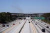
Two views looking northerly along Interstate
110 from the 120th Street overpass. In clear view from this
vantage point is the Judge Harry Pregerson Interchange that links the
Harbor Freeway to the Century Freeway by means of a dizzying array of
high-speed flyovers and connecting ramps. Also contained within
the interchange is a bus terminal for Metro's Siver Line, providing a
link to Metro's Green Line which is a light rail line in the median of
the Century Freeway.
This is one of the most awesome interchanges on
the planet. |
 |
|
High-res:
(1440x960)
(2400x1600) |
 |
|
Photographed by: AsphaltPlanet.ca |
Date: 3/27/2010 |
High-res:
(1440x960)
(2400x1600) |
|
Los Angeles County
City of Los Angeles
|
Pull through signage for the Century Freeway
interchange along the Harbor Freeway. |
 |
|
Photographed by: AsphaltPlanet.ca |
Date: 3/27/2010 |
High-res:
(1440x960)
(2400x1600) |
|
The 105 (Century Freeway) begins westerly from the
605 Freeway by-passing Downtown LA to the south, bound for LAX Airport.
Click here for Interstate 105
Images. |
|
Los Angeles County
City of Los Angeles
|
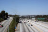
This view is only available to those who opt to
cruise Los Angeles County with a friend. This awesome view of the
Harbor Freeway, and Downtown LA is taken from the highspeed flyover ramp
that links the Carpool Lane on the eastbound Century Freeway to the
Carpool Lanes on the Harbor Freeway northbound. The San Gabriel
Mountain Range is clearly visible in the distance, beyond Downtown. |
|
|
Photographed by: AsphaltPlanet.ca |
Date: 3/26/2010 |
High-res:
(1440x960)
(2400x1600) |
|
Los Angeles County
City of Los Angeles
|
Southerly view of Interstate 110 as it passes
beneath Interstate 105. Note the height of the HOV flyover
ramp between the Century Freeway and the Harbor Freeway. |
 |
|
Photographed by: AsphaltPlanet.ca |
Date: 3/27/2010 |
High-res:
(1440x960)
(2400x1600) |
|
Los Angeles County
City of Los Angeles
|
Southbound signage for the general purpose ramps
to the Century Freeway. |
 |
|
Photographed by: AsphaltPlanet.ca |
Date: 3/27/2010 |
High-res:
(1440x960)
(2400x1600) |
|
Los Angeles County
City of Los Angeles
|
Overhead sign truss in advance of the Century
Freeway interchange. The Century/Harbor Freeway interchange is one
of the most complex interchanges in the world. Coupled with the
high speed flyovers for general purpose traffic, four high-speed ramps
link the HOV lanes north of the interchange on the Harbor Freeway to the
HOV lanes on both the east and west on the Century Freeway. |
 |
|
Photographed by: AsphaltPlanet.ca |
Date: 3/27/2010 |
High-res:
(1440x960)
(2400x1600) |
|
Los Angeles County
City of Los Angeles
|
Southbound advanced signage for the Carpool lane
ramps to the Century Freeway. Note the blank overheads over the
right side of the freeway as well. These signs flash 'Meter On'
during peak times when ramp meters are active for the ramps linking the
Century and Harbor Freeways. Numerous freeway to freeway ramps are
metered with traffic signals in Los Angeles County. |
 |
|
Photographed by: AsphaltPlanet.ca |
Date: 3/27/2010 |
High-res |
|
Los Angeles County
City of Los Angeles
|
Southbound signage for the Century Boulevard.
Neighbouring I-105 receives its colloquial name as the Century Freeway
due to its parallel alignment to Century Boulevard. |
 |
|
Photographed by: AsphaltPlanet.ca |
Date: 3/27/2010 |
High-res:
(1440x960)
(2400x1600) |
|
Los Angeles County
City of Los Angeles
|
Southbound view at the 51st Street exit. The
HOV lanes tower over the depressed freeway. |
 |
|
Photographed by: AsphaltPlanet.ca |
Date: 3/27/2010 |
High-res |
|
Los Angeles County
City of Los Angeles
|
View as Interstate 110 south descends into a
trench at the Vernon Street interchange. The Harbor Freeway is
situated below grade for just over a mile between Vernon Street and 54th
Street. Evidently, when the HOV lanes were constructed on the 110
Freeway, it was deemed to disruptive/expensive to widen the freeway
trench; so a four lane HOV structure was constructed and towers over the
general purpose lanes for about a mile. I-110 is one of Los Angeles County's most impressive
freeways. |
 |
|
Photographed by: AsphaltPlanet.ca |
Date: 3/27/2010 |
High-res |
|
Los Angeles County
City of Los Angeles
|
Advanced Northbound view at the northbound end of
the Harbor Freeway's Carpool lanes. The Silver Line (the Harbor
Freeway's bus route) exits the Harbor Freeway here continues northbound into Downtown L.A. on surface
streets. |
 |
|
Photographed by: AsphaltPlanet.ca |
Date: 3/26/2010 |
High-res:
(1440x960)
(2400x1600)
|
|
Los Angeles County
City of Los Angeles
|
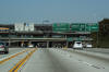
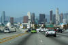
Into the general purpose lanes as the HOV lanes
have now ended, drivers are given a spectacular view of Downtown before
I-110 dives into a trench heading underneath of Adams Street. |
 |
|
Photographed by: AsphaltPlanet.ca |
Date: 3/26/2010 |
High-res:
(1440x960)
(2400x1600) |
|
Los Angeles County
City of Los Angeles
|
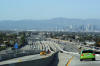
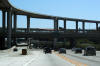
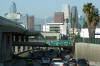
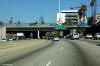
This is the concrete jungle! I-110
intersects with Interstate 10 a mile past the Adams Boulevard off-ramp. |
 |
|
Photographed by: AsphaltPlanet.ca |
Date: 3/26/2010 |
High-res:
(1440x960)
(2400x1600)
|
|
Los Angeles County
City of Los Angeles
|
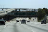
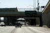
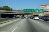
Southbound advanced signage for the Exposition
Boulevard interchange. Note the stub end of the Carpool lane
flyover -- obviously this structure was designed with a future extension
of the HOV lane system in mind; such an extension would be no small feet
as neither the Pasadena (CA-110), nor the Santa Monica (I-10) Freeways
have Carpool lanes. |
 |
|
Photographed by: AsphaltPlanet.ca |
Date: 3/27/2010 |
High-res:
(1440x960)
(2400x1600) |
|
Los Angeles County
City of Los Angeles
|
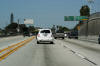
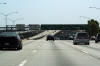
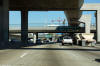
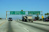
Signage for the Santa Monica Freeway interchange.
The overhead HOV structure creates a unique driving experience along the
110 Freeway. |
 |
|
Photographed by: AsphaltPlanet.ca |
Date: 10/30/2013 |
High-res:
(1440x960)
(2400x1600)
|
|
Los Angeles County
City of Los Angeles
|
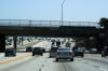
Interchange sequence signage affixed to the Adams Boulevard overpass. |
 |
|
Photographed by: AsphaltPlanet.ca |
Date: 10/30/2013 |
High-res:
(1440x960)
(2400x1600)
|
|
Los Angeles County
City of Los Angeles
|
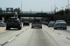
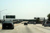
The first of two pull through lane assignment signs in advance of the
Santa Monica Freeway (I-10) interchange. |
 |
|
Photographed by: AsphaltPlanet.ca |
Date: 10/30/2013 |
High-res:
(1440x960)
(2400x1600)
|
|
Los Angeles County
City of Los Angeles
|
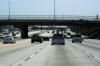
Pull-through signage at the Santa Monica Freeway
interchange. The interstate designation for Route 110 ends at the
Santa Monica Freeway. California Highway 110 continues northerly
past this interchange, continuing along the west side of Downtown as the
Harbor Freeway. |
 |
|
Photographed by: AsphaltPlanet.ca |
Date: 10/30/2013 |
High-res:
(1440x960)
(2400x1600)
|
|
The San Bernardino Freeway is the principal highway
linking Las Angeles and San Bernardino Counties.
Click here for
Interstate 10
Images. |