|
|
|
|
|
|
South-
Bound
|
|
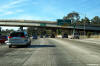
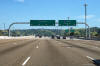
San Diego County
City of San Diego
|
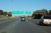
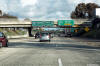
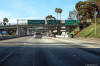
Northerly view at the off-ramp to I-805. |
 |
|
Photographed by: AsphaltPlanet.ca |
Date: 10/31/2013 |
High-res:
(1440x960)
(2400x1600)
|
|
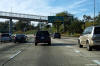
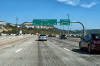
San Diego County
City of National City
|
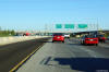
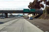
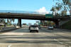
View looking northerly at the off-ramp to SR-54 East. |
 |
|
Photographed by: AsphaltPlanet.ca |
Date: 10/31/2013 |
High-res:
(1440x960)
(2400x1600)
|
|
Route 54 extends easterly into the eastern suburbs
of the San Diego Metro.
Click here for SR-54 Images. |
|
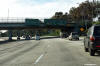
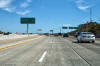
San Diego County
City of San Diego
|
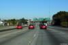
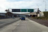
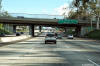
View looking at the northbound off-ramp to the 15 Freeway. |
 |
|
Photographed by: AsphaltPlanet.ca |
Date: 10/31/2013 |
High-res:
(1440x960)
(2400x1600)
|
|
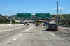
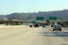
San Diego County
City of San Diego
|
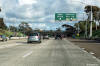
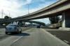
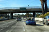
Southbound off-ramp at 28th Street and National Avenue. |
 |
|
Photographed by: AsphaltPlanet.ca |
Date: 4/10/2016 |
High-res:
(1440x960)
(2400x1600) |
|
San Diego County
City of San Diego
|
Southbound lane assignment signage just south of the SR-75 interchange
approaching 28th Street and National Avenue. |
 |
|
Photographed by: AsphaltPlanet.ca |
Date: 4/10/2016 |
High-res:
(1440x960)
(2400x1600) |
|
San Diego County
City of San Diego
|
Signage for the northbound off-ramp to SR-75 and the Coronado Bridge
interchange. |
 |
|
Photographed by: AsphaltPlanet.ca |
Date: 4/16/2017 |
High-res:
(1440x960)
(2400x1600)
|
|
San Diego County
City of San Diego
|
The northbound off-ramp to Cesar Chavez Parkway is situated within the
footprint of the Coronado Bridge interchange. |
 |
|
Photographed by: AsphaltPlanet.ca |
Date: 4/16/2017 |
High-res:
(1440x960)
(2400x1600)
|
|
San Diego County
City of San Diego
|
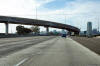
Two views looking northerly as Interstate 5 passes beneath the ramps
that carry traffic to and from the Coronado Bridge. |
 |
|
High-res:
(1440x960)
(2400x1600)
|
 |
|
Photographed by: AsphaltPlanet.ca |
Date: 4/16/2017 |
High-res:
(1440x960)
(2400x1600)
|
|
San Diego County
City of San Diego
|
Southbound view at the off-ramp to SR-75 and the Coronado Bay Bridge. |
 |
|
Photographed by: AsphaltPlanet.ca |
Date: 4/10/2016 |
High-res:
(1440x960)
(2400x1600) |
|
San Diego County
City of San Diego
|
Southerly view at the off-ramp to Cesar Chavez off-ramp |
 |
|
Photographed by: AsphaltPlanet.ca |
Date: 4/10/2016 |
High-res:
(1440x960)
(2400x1600) |
|
San Diego County
City of San Diego
|
Signage at the northbound off-ramp to SR-94. State Route 94 is the
Martin Luther King Jr. Freeway and runs easterly from Downtown San
Diego. |
 |
|
Photographed by: AsphaltPlanet.ca |
Date: 4/16/2017 |
High-res:
(1440x960)
(2400x1600)
|
|
San Diego County
City of San Diego
|
The northbound off-ramp to B Street and Pershing Drive is situated just
beyond the off-ramp to SR-94. |
 |
|
Photographed by: AsphaltPlanet.ca |
Date: 4/16/2017 |
High-res:
(1440x960)
(2400x1600)
|
|
Route 94 extends easterly towards Spring Valley and
beyond. Click here for
SR-94 Images. |
|
San Diego County
City of San Diego
|
Signage at the off-ramp to Imperial Avenue. |
 |
|
Photographed by: AsphaltPlanet.ca |
Date: 4/10/2016 |
High-res:
(1440x960)
(2400x1600) |
|
San Diego County
City of San Diego
|
A southbound advanced sign for the Cesar Chavez Parkway interchange is
situated just before the Imperial Avenue interchange. |
 |
|
Photographed by: AsphaltPlanet.ca |
Date: 4/10/2016 |
High-res:
(1440x960)
(2400x1600) |
|
San Diego County
City of San Diego
|
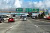
Interchange sequence signage approaching the SR-163 interchange. |
 |
|
Photographed by: AsphaltPlanet.ca |
Date: 4/16/2017 |
High-res:
(1440x960)
(2400x1600)
|
|
San Diego County
City of San Diego
|
First of several northbound advanced signs for the SR-163 interchange. |
 |
|
Photographed by: AsphaltPlanet.ca |
Date: 4/16/2017 |
High-res:
(1440x960)
(2400x1600)
|
|
San Diego County
City of San Diego
|
Additional northbound signage in advance of the SR-163 interchange. |
 |
|
Photographed by: AsphaltPlanet.ca |
Date: 4/16/2017 |
High-res:
(1440x960)
(2400x1600)
|
|
San Diego County
City of San Diego
|
Signage at the northbound off-ramp to the SR-163 interchange. |
 |
|
Photographed by: AsphaltPlanet.ca |
Date: 4/16/2017 |
High-res:
(1440x960)
(2400x1600)
|
|
Route 163 extends north from I-5 and Downtown San
Diego towards Interstate 15 at Miramar.
Click here for SR-163 Images. |
|
San Diego County
City of San Diego
|
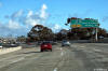
Southerly view at the I-805 interchange. The long ramp from the
Local Bypass to the northbound lanes of Interstate 805 towers over the
western side of the freeway interchange. |
 |
|
Photographed by: AsphaltPlanet.ca |
Date: 4/16/2017 |
High-res:
(1440x960)
(2400x1600) |
|
San Diego County
City of San Diego
|
Second of two advanced lane assignment signage approaching the
Interstate 805 interchange. |
 |
|
Photographed by: AsphaltPlanet.ca |
Date: 4/16/2017 |
High-res:
(1440x960)
(2400x1600) |
|
San Diego County
City of San Diego
|
First of two overhead lane assignment signs standing over the southbound
lanes of I-5 approaching the I-805 interchange. As is evident from
the lane assignment signage, the dominant movement at this interchange
carries traffic from I-5 south onto the southbound side of I-805. |
 |
|
Photographed by: AsphaltPlanet.ca |
Date: 4/16/2017 |
High-res:
(1440x960)
(2400x1600) |
|
San Diego County
City of San Diego
|
Southbound interchange sequence signage in advance of the I-805
interchange. |
 |
|
Photographed by: AsphaltPlanet.ca |
Date: 4/16/2017 |
High-res:
(1440x960)
(2400x1600) |
|
San Diego County
City of San Diego
|
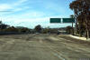
Southerly view at the off-ramp to the local lanes and Carmel Mountain
Road. The fly-over ramp from SR-56 dominates this freeway view. |
 |
|
Photographed by: AsphaltPlanet.ca |
Date: 10/30/2013 |
High-res:
(1440x960)
(2400x1600) |