King's Highway
102 - www.OntHighways.com
Highway 102 is a short-cut route,
shaving 15 kilometres of the route from Sistonen's Coreners to Thunder Bay, compared to Highway 11/17.
Before being designated Highway 102 in the 1970s, the route was known as King's
Highway 11A/17A, which (I think at least) better denoted that the route is in
fact an alternate to both Highways 11 and 17. Prior to downloading, Highway 102 continued east of the Thunder Bay expressway
into Downtown Port Arthur, where it ended at Highway 11B/17B (Cumberland
Street).
This is the second Highway 102 to be designated in
Ontario. The first existed in Hamilton in the 1950s and 60s. The
first highway 102 is now known as Cootes Drive.
For more
detailed information about Highway 102 in Hamilton, click
here (external link).
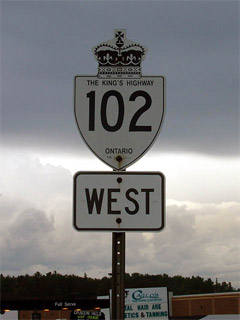
King's Highway 102 Shield
|
|
Western Terminus:
At the Highway 11/17 junction at Sistonen's Corners
|
Eastern Terminus: |
Current: Junction Highway 11/17 on the
Thunder Bay bypass. |
| |
Pre 1997: At Highway 11B/17B (Cumberland
Street) in downtown Port Arthur. |
Length:
Current: 33.0 km. Pre Downloading: 36.1
km
Multiplexes: None
Freeway: No
AADT (2002): Highest: 20,400 from
Strand Avenue in Thunder Bay to Highway 11/17 (Thunder Bay jct);
Lowest:
2,400 from Highway 11/17 at Sitsons Corners to the Thunder Bay twp western
limits
Road Info: Highway 102 is built
and maintained to Trans-Canada Highway standards for its entire length.
102 has a posted speed limit of 90km/h for its entire rural length. A
speed limit above 80km/h is pretty rare for undivided highways in Ontario,
and is only used for very well maintained routes. |
Communities and Major Intersections along Highway 102 from East to West:
|
Proper Municipality Name |
Community Name |
Distance |
Intersection Road |
|
District of Thunder Bay |
Sistonen's Corners |
0 km / 36.1 km |
King's Highway 11/17 |
|
City of Thunder Bay |
----- |
22.5 km / 13.6 km |
Mapleward Road |
|
City of Thunder Bay |
----- |
26.3 km / 9.8 km |
Secondary Highway 589 |
|
City of Thunder Bay |
North McIntyre |
--- |
Government Road |
|
City of Thunder Bay |
Thunder Bay |
--- |
Hilldale Road |
|
City of Thunder Bay |
Thunder Bay |
33.0 km / 3.1 km |
King's Highway 11/17 (Thunder Bay Expressway) |
|
CURRENT (1998) Eastern Terminus of Highway 102 |
|
The decommissioned portion of Highway 102 is known only as Red River Road in the
City of Thunder Bay |
|
City of Thunder Bay |
Thunder Bay (Port Arthur) |
--- |
Junot Street |
|
City of Thunder Bay |
Thunder Bay (Port Arthur) |
--- |
Algonquin Avenue |
|
City of Thunder Bay |
Thunder Bay (Port Arthur) |
--- |
High Street |
|
City of Thunder Bay |
Thunder Bay (Port Arthur) |
36.1 km / 0 km |
Highway 11B/17B (Cumberland Street) |
|
Highway 102 ENDS |
Highway 102 - Images
www.OntHighways.com - Home
Copyright (c) 2004,2005 Scott Steeves (Webmaster)
webmaster@onthighways.com
Page last updated: December 29th, 2004
Page created: December 29th, 2004