King's Highway 115 - www.OntHighways.com

Highway 115 serves as the four-lane connection between Peterborough and points Oshawa westerly.  Between Highway 35 and Peterborough, Highway 115 is a 4-lane freeway that was largely completed in the early 1990s.  South of Highway 35, Highway 115 is a RIRO expressway.  Its routing was changed slightly post provincial downloading:  A small section of Highway 115 lying in Peterborough along The Parkway was downloaded in April 1997; at that time Highway 115 ended at the Parkway interchange along the Peterborough bypass sharing a common terminus with the eastern segment of Highway 7.  In July 2003 Highway 115 was extended from the Parkway interchange to the northeast end of the Peterborough bypass.  Highway 7 is co-designated with Highway 115 for the length of this extension.


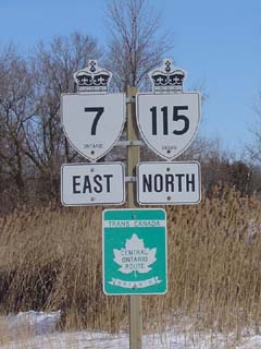
Highway 7/115 sign near Peterborough

  Southern Terminus:  Shared terminus with Highway 35 at the Highway 401 interchange west of Newcastle

Northern Terminus:  Current (After 2003): At the Lansdowne Street intersection at the east end of the Peterborough By-pass.
                                        1997-2003:  Sir Sandford Fleming Drive and Parkway interchange in Peterborough.
                                        Pre-1997: Junction Highway 7B (Monaghan Road) in Peterborough.

Length:  2003: 59.7 km.  1997-2003: 51.9km.  Pre-1997: 54.9km.

Multiplexes:  A sizable multiplex (20.4 km) with Highway 35 from Highway 401 to the north 35 split near Enterprise Hill.  A shorter (12.9 km) multiplex created in 2003 with Highway 7 to extend the Highway 115 moniker to the end of the bypass, and to fill in the small discontinuous section of Highway 7.  Before Summer 2003 Highway 115 was multiplexed with Highway 7A for 4.5km, and prior to 1997, 115 was multiplexed with Highway 28 for approx 10 km.

Freeway:  Highway 115 is a high speed divided highway for its entire length.  The 35/115 is a RIRO expressway with both homes and businesses adjacent to the divided highway for about 20 km.  The remainder of Highway 115 (39.3 km) is a freeway

AADT  (2002):  Highest: 27,500, from Clark 3rd line to Clark 4th Line;

                              Lowest:  16,900 from Highway 35 to Highway 7A.

Road info:  Highway 115 is well surfaced for its entire length.  The RIRO section has a posted speed limit of 90km/h.  For the freeway segment, a 100km/h limit has been posted.  While at most times Highway 115 is fairly lightly traveled, the highway is an important route to the Kawartha Lakes and Cottage country and can be quite busy during peak periods in the summer. 


Highway 115 information:


OntHighways.com  

Detailed Route information available below
Virtual Tour of Highway 115


TheKingsHighway.ca   History of Highway 115
Photographic History of Highway 115

Current Interchanges and RIRO's along Highway 115 from South to North:

Proper Municipality Name Community Name Distance Interchange or RIRO
Municipality of Clarington ----- 0 km / 59.7 km King's Highway 401 (Autoroute Macdonald - Cartier Freeway)
Municipality of Clarington ----- --- Lovkin Road (RIRO exit)
Municipality of Clarington ----- 1.3 km / 58.4 km Highway 2 (full interchange)
Municipality of Clarington ----- 6.1 km / 53.6 km Mill Street (Durham Road 17 South) & Concession Road 3
Municipality of Clarington ----- 8.1 km / 51.6 km Concession Road 4
Municipality of Clarington Orono 9.7 km / 50.0 km Mill Street (Durham Road 17 North)
Municipality of Clarington Orono --- Station Street - NO TURN AROUND FOR 35/115
Municipality of Clarington Orono --- Mill Street & Tamblyn Road
Municipality of Clarington Orono 12.7 km / 47.0 km Taunton Road (Durham Road 4) & 6th Concession Road
Municipality of Clarington Kirby 15.1 km / 44.6 km 7th Concession Road & Ganaraska Road (Durham Road 9)
Municipality of Clarington ----- 17.1 km / 42.6 km 8th Concession Road
Municipality of Clarington ----- --- Wilcox Road (East Side partial interchange). - NO TURN AROUND FOR 35/115
Municipality of Clarington ----- 20.4 km / 39.3 km King's Highway 35-North.
Clarington - Kawartha Lakes Boundary ----- --- Boundary Road
City of Kawartha Lakes ----- 28.3 km / 31.4 km Porter Road (Kawartha Lakes Road 32)
Cavan- Millbrook- North Monaghan ----- --- Tapley Quarter Line
Cavan- Millbrook- North Monaghan ----- --- Peterborough Road 10
Cavan- Millbrook- North Monaghan ----- 42.3 km / 17.4 km King's Highway 7A-West
Cavan- Millbrook- North Monaghan ----- 46.8 km / 12.9 km Highway 28 (Peterborough Road 28) &  King's Highway 7-West
Cavan- Millbrook- North Monaghan ----- --- Airport Road
City of Peterborough Peterborough Bypass 53.2 km / 6.5 km The Parkway & Sir Sandford Fleming Drive
City of Peterborough Peterborough Bypass --- Burnham Street
City of Peterborough Peterborough Bypass --- Ashburnaham Road
City of Peterborough Peterborough Bypass 59.7 km / 0 km King's Highway 7-East & Lansdowne Street (Former Highway 7B) & Television Road.

Highway 115 ENDS


<- Highway 112         www.OntHighways.com - Home         Highway 117 ->


Copyright (c) 2004-2010, AsphaltPlanet.ca  AsphaltPlanet@asphaltplanet.ca

Page last updated:  March 6th, 2007

Page created:  March 11th, 2004