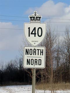
King's Highway
140 - www.OntHighways.com
King's Highway 140 is a short
highway that connects Welland to Port Colborne on the east side of the Welland
Canal. Highway 140 was unaffected by provincial downloading. In the
future, Highway 140 could possibly be incorporated into a future southern Highway 406
extension.

New Style King's Highway 140 Shield
|
|
Southern Terminus: At the Highway 3
junction just east of Port Colborne.
Northern Terminus: At the East Main
Street Junction just east of Welland.
Length: 9.3 km
Multiplexes: None
Freeway: No
AADT (2002):
Highest: 9,850, from Buchner Road to East Main Street in Welland;
Lowest: 6,450, from Highway 3 northerly to Niagara Road 23.
Road Info: Highway 140 is a busy,
but well maintained route for its entire length. The entire length of
Highway 140 has a posted speed limit of 80km/h. |
Communities and Major Intersections along Highway 140 from South to North:
|
Proper Municipality Name |
Community Name |
Distance |
Intersecting Road |
| City of Port Colborne |
----- |
0 km / 9.3 km |
King's Highway 3
& Niagara Road 140 |
| City of Port Colborne |
----- |
4.1 km / 5.2 km |
Forks Road (Niagara Road 23) |
| City of Welland |
----- |
6.1 km / 3.2 km |
King's Highway 58A |
| City of Welland |
----- |
9.3 km / 0 km |
East Main Street (Highway 7146 & Niagara Road
27) |
|
Highway 140 ENDS |
<- Highway
138 www.OntHighways.com - Home
Highway 141 ->
Copyright (c) 2004-2010, AsphaltPlanet.ca
AsphaltPlanet@asphaltplanet.ca
Page last updated: February 25th, 2005
Page created: February 25th, 2005
