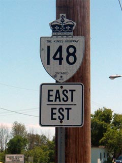
King's Highway
148 -
O N T H I G H W A Y S
Before downloading, Highway 148
connected Highway 17 at the Highway 62 junction with Quebec Highway 148, via
Downtown Pembroke, and the Pembroke-Allumette Bridge. In 1998, all
portions of Highway 148 west of MacKay Street (Highway 41) were formally
decommissioned. These sections are now known as Renfrew Road 58, Trafalgar
Street, and Pembroke Street. Interestingly, all of Highway 148 was once
part of Highway 62. Highway 62 was renumbered to 148 east of the Pembroke
Bypass shortly after the Bypass was constructed. This renumbering more
logically guides travelers to and from Quebec Highway 148. Also of
interest, Highway 148 follows the original alignment of Highway 17 through
Downtown Pembroke before the Pembroke Bypass was completed in the early 1980s.
 Old Style King's
Highway 148
Shield.
Image Courtesy:
Josh Anderchek
|
|
Western Terminus:
Pre-1998: Highway 148 ended at the Highway
17/62 junction on the Pembroke Bypass.
Current:
Highway 148 ends at Highway 41 (MacKay Street) in downtown Pembroke.
Eastern Terminus: Highway 148
connects to PQ Highway 148 in Quebec. Highway 148 ends at the Allumette
Bridge
Length:
Pre-1998: 14.4 km. Current: 6.2 km
Multiplexes: None.
Freeway: No
AADT
(2002): Highest: 10,000, from Pembroke easterly to Renfrew Road
21;
Lowest: 4,800, from Renfrew Road 40 easterly to the Ontario-Quebec Boundary.
Road Info: Highway 148 is in good
condition for its entire current length. Between Pembroke and Renfrew
Road 21, the highway is built to very modern standard and is fairly busy.
East of Renfrew Road 21 traffic is much more moderate, and the road is built
to an older standard. Interestingly the portion of Highway 148 east of
Renfrew Road 21 was built in conjunction with PQ-148, and could have very
easily been incorporated into the ill-fated Autoroute-50 extension. |
Click here to
scroll to Current Route information
Communities and Major Intersections along Highway 77 from South to North:
|
Proper Municipality
Name |
Community Name |
Distance |
Major Intersection |
|
The downloaded portion of Highway
148 outside of Pembroke is known as Renfrew Road 58. |
| Township of Laurentian Valley |
----- |
0 km / 14.4 km |
King's Highway 17 &
Highway 62 (Renfrew Road 58) |
| Township of Laurentian Valley |
----- |
1.3 km / 13.1 km |
B-Line Road |
| Township of Laurentian Valley |
Brumsfield |
3.9 km / 10.5 km |
Renfrew Road 36 |
|
At Boundary Road: EB: Turn
Left onto Boundary Road, then Right onto Trafalgar Road. WB: Turn Left
onto Boundary Road, then Right onto Bruham Avenue. |
| Laurentian Valley - Pembroke Boundary |
Pembroke West Limits |
5.3 km / 9.1 km |
Boundary Road (Renfrew Road 35) |
|
At Pembroke Street-West:
EB: Turn Right onto Pembroke Street. WB: Turn left of of Pembroke
Street onto Trafalgar Road |
| City of Pembroke |
Pembroke |
--- |
Pembroke Street (West) |
|
Current
Western Terminus of
Highway 148 is located at Highway 41 (MacKay Street) |
| City of Pembroke |
Pembroke |
8.2 km / 6.2 km |
King's Highway 41
(MacKay Street) |
| Pembroke - Laurentian Valley Boundary |
Pembroke East Limits |
9.5 km / 4.9 km |
----- |
| Township of Laurentian Valley |
Pleasant View |
11.1 km / 3.3 km |
Drive-In Road (Renfrew Road 29) |
|
At Renfrew Road 21: EB:
Turn Left towards Quebec. EB: Ramp right towards Pembroke |
| Township of Laurentian Valley |
----- |
12.6 km / 1.8 km |
Renfrew Road 21 |
| Ontario - Quebec Boundary |
----- |
14.4 km / 0 km |
Quebec Highway 148 |
|
Highway 148 ENDS |
Highway 148 - Images
O N T
H I G H W A Y S - Home
Copyright (c) 2004-2010, AsphaltPlanet.ca
AsphaltPlanet@asphaltplanet.ca
Page last updated: May 30th, 2005
Page created: May 19th, 2005