|
Proper Municipality Name |
Community Name |
Distance |
Intersection Road |
|
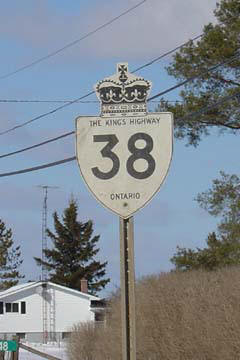
Highway 38 is known as Gardiner's Road (Frontenac
Road 6) from Highway 2 northerly to Centennial Road |
|
City of Kingston |
Cataraqui |
0 km / 70.0 km |
Highway 2 (Kingston Road 2, Princess Street) |
|
North of Centennial Road Highway
38 is still posted with provincial shields, Highway 38 is likely known as
'Highway 38' in both Kingston and South Frontenac |
|
City of Kingston |
----- |
3.0 km / 67.0 km |
King's Highway 401 (Autoroute
M-C Freeway) |
|
City of Kingston |
Glenvale |
8.3 km / 61.7 km |
Sharpton Road (Frontenac Road 4) |
|
Township of South Frontenac |
Murvale |
--- |
----- |
|
Township of South Frontenac |
----- |
15.3 km / 54.7 km |
Yarker Road (Frontenac Road 4) |
|
Township of South Frontenac |
Harrowsmith |
19.5 km / 50.5 km |
Wilton Road (Frontenac Road 18) |
|
Township of South Frontenac |
Harrowsmith |
19.6 km / 50.4 km |
Harrowsmith Road (Frontenac
Road 5) |
|
Township of South Frontenac |
Hartington |
--- |
----- |
|
Township of South Frontenac |
----- |
27.9 km / 42.1 km |
Bellrock Road (Frontenac Road 7) |
|
Township of South Frontenac |
Verona |
--- |
----- |
|
Township of South Frontenac |
----- |
30.3 km / 39.7 km |
Desert Lake Road (Frontenac Road 19) |
|
Central Frontenac - South Frontenac Boundary |
Piccadilly |
--- |
----- |
|
Township of Central Frontenac |
Godfrey |
36.2 km / 33.8 km |
Westport Road (Frontenac Road 8) |
|
Township of Central Frontenac |
Cole Lake |
--- |
----- |
|
In Parkham: NB: Take the
short ramp to the right to continue to northwards to Sharbot Lake. SB:
Turn left towards Kigston. |
|
Township of Central Frontenac |
Parham |
50.5 km / 19.5 km |
Wagerville Road |
|
Township of Central Frontenac |
Tichbone |
--- |
----- |
|
Township of Central Frontenac |
Octono |
--- |
----- |
|
Township of Central Frontenac |
----- |
60.6 km / 9.4 km |
Crow Lake Road |
|
Township of Central Frontenac |
Sharbot Lake |
--- |
----- |
|
Township of Central Frontenac |
----- |
70.0 km / 0 km |
King's Highway 7 (TCH: Central
Ontario Route) |
|
Highway
38 ENDS |