|
Proper
Municipality Name |
Community Name |
Distance |
Intersecting Road |
|
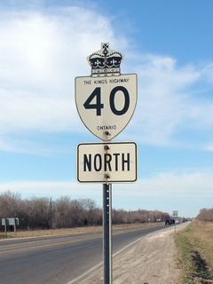
South of Highway 401, Highway 40
is known as Chatham-Kent Road 11, Communications Line. |
| City of Chatham-Kent |
Blenheim |
(0km) / (103.1km) |
Highway 3 (Chatham-Kent
Road 3, Marlborough Road) |
| City of Chatham-Kent |
(Former) Blenheim North Limits |
(1.0 km) / (128.2 km) |
----- |
|
Current Southern (1998) Terminus
of Highway 40 |
| City of Chatham-Kent |
------ |
(9.9km) / (93.2km) |
King's Highway 401 (Autoroute
Macdonald-Cartier Freeway) |
| City of Chatham-Kent |
----- |
(10.2km) / (92.9km) |
Chatham-Kent Road 14-East |
| City of Chatham-Kent |
------ |
(11.4km) / (91.7km) |
Chatham-Kent Road 14-West |
| City of Chatham-Kent |
----- |
(15.5km) / (87.9km) |
Chatham-Kent Road 18-East |
| City of Chatham-Kent |
(Former)
Chatham South Limits |
(16.1km) / (87.0km) |
Chatham-Kent Road 18-West (former alignment of
Highway 40 North) |
|
At Longwoods Road: NB:
Turn Left towards Wallaceburg. SB: Turn Right towards Highway 401. |
| City of Chatham-Kent |
Chatham |
--- |
Highway 2-East (Chatham-Kent Road 2, Longwoods
Road) & Prince Edwards Road (Chatham-Kent Road 30) |
|
At Grand Avenue: NB:
Turn Right towards Wallaceburg. SB: Turn Left towards Highway 401. |
| City of Chatham-Kent |
Chatham |
(22.2km) / (80.9km) |
Highway 2-West (Chatham-Kent Road 2, Grand
Avenue) |
| City of Chatham-Kent |
(Former)
Chatham North Limits |
(25.5km) / (77.6km) |
----- |
| City of Chatham-Kent |
----- |
(29.0km / (74.1km) |
Chatham-Kent Road 35 |
| City of Chatham-Kent |
Oungah |
(33.3km) / (69.8km) |
Countryview Line (Chatham-Kent Road 29) |
| City of Chatham-Kent |
----- |
(40.4km) / (62.7km) |
Chatham-Kent Road 42 (Electric
Line & Oilfield Line) |
| City of Chatham-Kent |
(Former)
Wallaceburg South Limits |
(47.7km) / (55.4km) |
Base Line (Chatham-Kent Road 15) |
|
At Highway 78: NB:
Turn Left towards Sarnia. SB: Turn Right towards Chatham. |
| City of Chatham-Kent |
Wallaceburg |
(49.5km) / (53.6km) |
Highway 78 (Chatham-Kent Road 78, James Street) |
| City of Chatham-Kent |
(Former)
Wallaceburg West Limits |
(51.4km) / (51.7km) |
----- |
|
At Kent Road 33: NB:
Follow the ramp to the right towards Sarnia. SB: Turn Leftt towards
Wallaceburg. |
| City of Chatham-Kent |
----- |
(60.1km) /
(43.0km) |
(Dufferin Avenue) Kent Road 33 |
| Township of St. Clair |
----- |
(64.1km) / (39.0km) |
Lambton Road 1 |
| Township of St. Clair |
----- |
(66.9km) / (36.2km) |
Lambton Road 28 |
| Township of St. Clair |
----- |
--- |
Bentpath Line (Lambton Road 2) |
| Township of St. Clair |
----- |
--- |
Bickford Line (Lambton Road 36) |
| Township of St. Clair |
----- |
(77.7km) / (25.4km) |
Highway 80 (Lambton Road 80, Courtright Line) |
| Township of St. Clair |
----- |
(85.7km) / (17.4km) |
Petrolia Line (Lambton Road 4) |
| St. Clair / Sarnia Boundary |
Sarnia South
Limits |
(88.4km) / (14.7km) |
----- |
|
At Churchill Line: NB:
Follow the ramp to the right towards Highway 402. SB: Turn Left
towards Wallaceburg. |
| City of Sarnia |
Sarnia |
(91.2km) / (11.9km) |
Churchill Line (Old Highway 40) |
| City of Sarnia |
(Former) Sarnia East
Limits |
(93.9km) / (9.2km) |
Indian Line |
| City of Sarnia |
----- |
(96.3km) / (6.8km) |
Park Road (Lambton Road 20) |
| City of Sarnia |
----- |
(99.0km) /
(4.1km) |
Confederation Street (Lambton Road 25) |
| City of Sarnia |
----- |
(100.4km) / (2.7km) |
Wellington Street (Lambton Road 17) |
| City of Sarnia |
----- |
(101.8km) / (1.3km) |
Highway 7 (Lambton Road 22, London Line) |
| City of Sarnia |
----- |
(102.5km) / (0.6km) |
King's Highway 402 |
| City of Sarnia |
----- |
(103.1km) / (0km) |
Modeland Road |
|
Highway 40 ENDS |