King's Highway 74 - www.OntHighways.com

King's Highway 74 runs from New Sarum northerly through Belmont to Nilestown.  Highway 74 was one of the more logical highway transfers that took place in the late 1990s.  Highway 74 was decommissioned on April 1st, 1997.  This route was certainly among the least 'provincially significant' highways in the system.


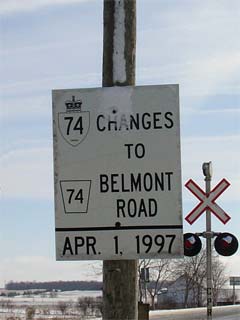
King's Highway 74 Changes to County Road 74, effective April 1, 1997

  Southern Terminus:  At the Highway 3 junction on the New Sarum Bypass.

Northern Terminus:  Highway 74 ends at the Hamilton Road junction in Nilestown.

Length:   22.4 km

Multiplexes:  None

Freeway: No

AADT (1994):  Highest:  4,500, from Belmont northerly to Highway 401;

                             Lowest:  2,900 from Highway 3 northerly to Belmont.

Status:  Totally downloaded in 1997.  Now known as Elgin Road 74, and Middlesex Road 74.

Road Info:  Highway 74 is good shape for its entire length, though it was last been rehabilitated by the counties that now maintain it, and not the MTO.  Traffic is moderate for the entire length of Highway 74.


Highway 74 information:


OntHighways.com  

Detailed Route information available below
Virtual Tour of Highway 74 (Coming Soon!)


TheKingsHighway.ca   History of Highway 74
Photographic History of Highway 74

Communities and Major Intersections along Highway 74 from South to North:

Proper Municipality Name Community Name Distance Intersecting Road

In Elgin County, Highway 74 is now known as Elgin Road 74

Municipality of Central Elgin New Sarum Bypass 0 km / 22.4 km King's Highway 3 (Talbot Street)
Municipality of Central Elgin New Sarum --- -----
Central Elgin - Malahide Boundary ----- --- Ron McNeil Line (Elgin Road 52)
Central Elgin - Malahide Boundary Mapleton --- -----
Central Elgin - Malahide Boundary ----- --- Elgin Road 48 (Ferguson Line & Lyons Line)
Municipality of Central Elgin Belmont South Limits 11.6 km / 10.8 km Borden Avenue (Elgin Road 34)
Municipality of Central Elgin Belmont --- Caesar Road (Elgin Road 37)

The north limits of Belmont is also the boundary between Elgin and Middlesex.  Highway 74 is now known as Middlesex Road 74

Central Elgin - Thames Centre Boundary Belmont North Limits 12.7 km / 9.7 km -----
Municipality of Thames Centre Derwent --- -----
Municipality of Thames Centre ----- --- Wilton Grove Road (Middlesex Road 26)
Municipality of Thames Centre ----- 19.5 km / 2.9 km King's Highway 401 (Autoroute Macdonald-Cartier Freeway)
Municipality of Thames Centre Nilestown 22.4 km / 0 km Hamilton Road (Middlesex Road 29) & Westchester Bourne-North (Middlesex Road 74, formerly Middlesex Road 25)

Highway 74 ENDS


<- Highway 73         www.OntHighways.com - Home         Highway 76 ->


Copyright (c) 2004-2010, AsphaltPlanet.ca  AsphaltPlanet@asphaltplanet.ca

Page last updated:  May 20th, 2007

Page created:  February 4th, 2005