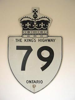
|
Proper Municipality
Name |
Community Name |
Distance |
Major Intersection |
|
Chatham-Kent has designated its
portion of Highway 79 as County Road 16. |
| Municipality of Chatham-Kent |
----- |
--- (0km) / --- (77.5km) |
Highway 2 (Chatham-Kent Road 2, Longwoods Road) |
| Municipality of Chatham-Kent |
(Former) Bothwell South Limits |
--- (2.1km) / --- (75.4km) |
Centre Line (Chatham-Kent Road 24) |
| Municipality of Chatham-Kent |
(Former) Bothwell North Limits |
--- (3.5km) / --- (74.0km) |
----- |
|
At Main Line: NB: Turn Left
staying on Chatham-Kent Road 16, followed by a right turn at the railway
tracks. SB: Turn left as the road ends, follow the ramp to the right
away from Bothwell. |
| Municipality of Chatham-Kent |
----- |
--- (5.1km) / --- (72.0km) |
Main Line (Chatham-Kent Road 22) |
|
Chatham-Kent - Lambton Boundary:
NB: Highway 79 is known as Lambton Road 79. SB: Chatham-Kent has
re-designated Highway 79 as Chatham-Kent Road 16. |
| Chatham-Kent - Lambton Boundary |
----- |
--- |
----- |
| Township of Dawn-Euphemia |
Cairo |
--- (12.0km) / --- (65.5km) |
Lambton Road 2 |
| Dawn-Eupemia - Brooke-Alvinston Boundary |
Aughrim |
--- |
----- |
| Township of Brooke-Alvinston |
----- |
--- (24.9km) / --- (52.6km) |
Highway 80 (Lambton Road 80) |
| Township of Brooke-Alvinston |
(Former) Alvinston South Limits |
--- (25.7km) / --- (51.8km) |
----- |
| Township of Brooke-Alvinston |
Alviston |
--- (26.3km) / --- (51.2km) |
Lambton Road 23 |
| Township of Brooke-Alvinston |
(Former) Alviston North Limits |
--- (27.0km) / --- (50.5km) |
----- |
| Township of Brooke-Alvinston |
----- |
--- (33.3km) / --- (44.2km) |
Lambton Road 4 |
| Township of Warwick |
(Former) Watford South Limits |
--- (40.1km) / --- (37.4km) |
----- |
| Township of Warwick |
(Former) Watford North Limits |
--- (41.3km) / --- (36.2km) |
Confederation Line (Lambton Road 39) |
| Township of Warwick |
(Former) Watford North Limits |
--- (45.3km) / --- (32.2km) |
King's Highway 402 |
|
At Lambton Road 22-West:
NB: Follow the ramp to the right towards London. SB: Turn Left towards
Watford |
| Township of Warwick |
----- |
--- (46.7km) / --- (30.8km) |
Highway 7-West (Lambton Road 22-West) |
|
At Highway 22 (Lambton Road
22-East): NB: Turn Left towards Arkona. SB: Follow the ramp to
the right towards Sarnia. |
| Township of Warwick |
----- |
--- (50.4km) / --- (27.1km) |
Highway 22 (Lambton Road 22-East) |
| Warwick - Lambton Shores Boundary |
(Former) Arkona South Limits |
--- (58.km) / --- (19.5km) |
----- |
| Municipality of Lambton Shores |
Arkona |
--- (58.2km) / --- (19.3km) |
Townsend Line (Lambton Road 12) |
| Municipality of Lambton Shores |
(Former) Arkona North Limits |
--- (59.0km) / --- (18.5km) |
----- |
| Municipality of Lambton Shores |
----- |
--- (66.7km) / --- (10.8km |
Highway 7-East (Lambton Road 6, TO Middlesex Road 7)
& Thompson Line (Lambton Road 6) |
| Municipality of Lambton Shores |
(Former) Thedford South Limits |
--- (67.9km) / --- (9.6km) |
----- |
|
At Highway 22 (Lambton Road
22-East): NB: Turn Left towards Arkona. SB: Follow the ramp to
the right towards Sarnia. |
| Municipality of Lambton Shores |
Thedford |
--- |
----- |
| Municipality of Lambton Shores |
----- |
--- (72.8km) / --- (4.7km) |
Lambton Road 9 |
| Municipality of Lambton Shores |
----- |
--- (76.4km) / --- (1.1km) |
Lambton Road 18 |
| Municipality of Lambton Shores |
----- |
--- (77.5km) /--- (0km) |
King's Highway 21 |
|
Highway 79 ENDS |
