AsphaltPlanet.ca > OntHighways > Highway 90 > Images
< Hwy 89    Hwy 91 >

King's Highway 90 - www.OntHighways.com

Like Highway 42, Highway 90 has its western terminus at a destination rather than at another provincial highway.  Unlike Highway 42, Highway 90 has a logical western terminus.  Highway 90 leads from the City of Barrie and from Highway 400 westerly to Angus, and CFB Borden.  CFB Borden is an important installation for Canadian Forces.  It is one of the largest bases in Ontario, and certainly the largest within Central Ontario.  Highway 90 was a short highway that was transferred to the City of Barrie and County of Simcoe on January 1, 1998.


Highway 90 Junction crown

  Western Terminus:  Camp Borden Road/Simcoe Road 10-South, in Angus.

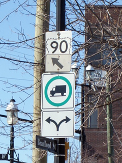
Eastern Terminus:  Junction Highway 11/27 at Bradford Street in Downtown Barrie.

Length:  19.0km

Multiplexes:  None

Freeway: No

AADT (1994):  Highest:  15,200, from Simcoe Road 28 easterly to Highway 131;

                             Lowest:  12,000, from Angus easterly to Simcoe Road 28.

Status:  Totally downloaded in 1998, now known as Simcoe Road 90 and Dunlop Street in Barrie.

Road Info: Highway 90 is very good condition for its entire length.  It was in good shape when the MTO owned it, and Simcoe County has done well to upkeep the road.  With a few notable surprises, Simcoe County maintains a good county road network, impressive given how large the county is, and just how extensive their network is.  Travelers should expect a lot of traffic along Highway 90, with no shortage of trucks.  The Highway 400 interchange is quite old and doesn't handle traffic all that efficiently.  Dunlop Street east of the 400 is riddled with traffic signals and is not an efficient drive into Downtown Barrie.  (Of course, any seasoned traveler will know that efficient drives are hard to come by in Barrie).  Highway 90 has a posted speed limit of 80km/h outside of urban areas.


Highway 90 information:


OntHighways.com  

Detailed Route information available below
Virtual Tour of Highway 90


TheKingsHighway.ca   History of Highway 90
Photographic History of Highway 90

Communities and Major Intersections Located on Highway 90 from West to East:

Proper Municipality Name Community Name Distance Intersection Name

Highway 90 is signed as Simcoe Road 90.

CFB Borden / Essa Boundary Angus (Camp Borden) 0km / 19.0km Simcoe Road 10-South & Camp Borden Road
Township of Essa Angus 1.9km / 17.1km Simcoe Road 10-North
Essa / Springwater Boundary ----- --- Sunnidale Road (Simcoe Road 40)
Essa / Springwater Boundary Essa 7.4km / 11.6km Simcoe Road 56
Essa / Springwater Boundary ----- 12.1km / 6.9km Simcoe Road 28
Essa / Springwater Boundary ----- 13.9km / 5.1km Highway 131 (Simcoe Road 27-South)
Essa / Springwater / Barrie Boundary Barrie West Limits 14.9km / 4.1km -----
City of Barrie Barrie 17.4km / 1.6km King's Highway 400
City of Barrie Barrie 19.0km / 0km Highway 11&27 (Bradford Street)

Highway 90 ENDS


<- Highway 89         www.OntHighways.com - Home         Highway 91 ->


Copyright (c) 2004-2010, AsphaltPlanet.ca  AsphaltPlanet@asphaltplanet.ca

Page last updated:  June 9th, 2010

Page created:  June 9th, 2010