|
Proper Municipality
Name |
Community Name |
Distance* |
Major Intersection |
|
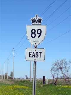
Highway 89 south of Highway 9 at
Harriston was incorporated into Highway 23 in late 2004. Click
here for Highway 23
information |
| Town of Minto |
----- |
--- (0km) / --- (122.1km) |
King's Highway 23
/ Wellington Road 123/Perth Road 93 |
|
At Highway 87: SB: Turn
Left towards Palmerston. NB: Follow the ramp to the right towards
Harriston |
| Town of Minto |
----- |
--- (8.1km) / --- (114.0km) |
Highway 87 (Wellington Road 87) |
|
Current
(Since 2004) Western Terminus of Highway 89 is located at Highway 9/23
junction in Harriston |
| Town of Minto |
Harriston |
0km (9.7km) / 107.0km (112.4km) |
King's Highway 9/Dufferin Road 109 &
King's Highway 23 |
| Town of Minto |
(Former) Harriston East
Limits |
0.5km (10.2km) / 106.4km
(111.9km) |
----- |
| Town of Minto |
----- |
5.3km (15.0km) / 101.7km
(107.1km) |
Wellington Road 2 |
| Wellington North - Southgate Boundary |
----- |
13.6km (23.3km) / 93.4km (98.8km) |
Wellington Road 6 & Grey Road 6 |
| Wellington North - Southgate Boundary |
(Former) Mount Forest West
Limits |
15.0km (24.7km) / 92.0km (97.4km) |
Sligo Road (Grey Road 106) |
| Township of Wellington North |
Mount Forest |
16.8km (26.5km) / 90.2km (95.6km) |
King's Highway 6
(Main Street) |
| Wellington North - Southgate Boundary |
(Former) Mount Forest East
Limits |
18.2km (27.9km) / 98.8km (94.2km) |
----- |
| Wellington North - Southgate Boundary |
Clare |
--- |
----- |
| Wellington North - Southgate Boundary |
Conn |
30.2km (39.9km) / 76.8km (82.2km) |
Wellington Road 14 & Grey Road 14 |
| Wellington North - Southgate Boundary |
----- |
35.4km (45.3km) / 71.4km (76.8km) |
Wellington Road 16 |
| Wellington North - Southgate Boundary |
Egerton |
--- |
----- |
| Wellington North - Southgate Boundary |
Signet |
--- |
----- |
| Southgate - East Luther Grand Valley Boundary |
----- |
44.3km (54.0km) / 62.7km (68.1km) |
Grey Road 8 |
| Southgate - East Luther Grand Valley Boundary |
Keldon |
--- |
----- |
| Melancthon - East Luther Grand Valley Boundary |
----- |
48.3km (58.2km) / 58.5km (63.9km) |
Highway 25 (Dufferin Road 25) |
| Melancthon - Amaranth Boundary |
Jessopville |
--- |
----- |
| Melancthon - Amaranth Boundary |
----- |
51.0km (60.7km) / 56.0km (61.4km) |
Dufferin Road 17 |
| Melancthon - Amaranth Boundary |
----- |
--- |
Dufferin Road 12 |
| Melancthon - Amaranth - Shelburne Boundary |
Shelburne West Limits |
60.1km (69.8km) / 46.9 km
(52.3km) |
----- |
| Town of Shelburne |
Shelburne |
60.9km (70.6km) / 46.1km (51.5km) |
King's Highway 10-North
(Owen Sound Street) |
| Shelburne - Melancthon - Amaranth Boundary |
Shelburne East Limits |
62.2km (71.9km) / 44.8km (50.2km) |
Highway 24-North
(Dufferin Road 124) & Dufferin Road 11 |
| Mulmer - Mono Boundary |
Primrose |
66.2km (75.9km) / 40.8km (46.2km) |
King's Highway 10-South/Highway 24-South
& Dufferin Road 19 |
| Mulmer - Mono Boundary |
Violet Hill |
--- |
----- |
| Mulmer - Mono Boundary |
----- |
75.7km (85.4km) / 31.3km (36.7km) |
Airport Road (Dufferin Road 18) |
| Mulmer - Mono Boundary |
Mulmer |
--- |
----- |
| Dufferin Co. - Simcoe Co. Boundary |
Rosemont |
78.3km (88.0km) / 28.7km (34.1km) |
----- |
| Township of Adjala- Tosorontio |
----- |
84.0km (93.7km) / 23.0km (28.4km) |
Everett Road (Simcoe Road 13) |
| Township of Adjala- Tosorontio |
----- |
85.1km (94.8km) / 21.9km (27.3km) |
Highway 50 (Simcoe Road 50) |
| Town of New Tecumseth |
Alliston |
88.1km (97.4km) / 19.6km (25.0km) |
Industrial Parkway |
|
At King Street South: EB:
Turn Left towards Downtown Alliston. WB: Follow the ramp to the right
towards Shelburne |
| Town of New Tecumseth |
Alliston |
--- |
King Street-South |
|
At King Street North: EB:
Turn Right towards Downtown. WB: Turn Left towards Shelburne |
| Town of New Tecumseth |
Alliston |
88.6km (97.9km) / 18.8km (24.2km) |
King Street-North (To Simcoe Road 15) |
| Town of New Tecumseth |
Alliston |
91.4km (101.1km) / 15.6km
(21.0km) |
Tottenham Road (Simcoe Road 10-South) |
| Essa - New Tecumseth Boundary |
----- |
92.4km (102.1km) / 14.6km
(20.0km) |
Simcoe Road 10-North |
| Essa - New Tecumseth Boundary |
Nicolston |
--- |
----- |
| Essa - New Tecumseth Boundary |
----- |
96.7km (106.4km) / 10.3km
(15.7km) |
Simcoe Road 56 |
| Town of Innisfil |
(Former) Cookstown West
Limits |
102.5km (112.2km) / 4.5km (9.9km) |
----- |
| Town of Innisfil |
Cookstown |
102.9 km (112.8km) / 3.9km
(9.3km) |
Highway 27 (Simcoe Road 27) |
| Town of Innisfil |
(Former) Cookstown East
Limits |
103.7km (113.4km) / 3.3km (8.7km) |
----- |
| Town of Innisfil |
----- |
106.2km (115.9km) / 0.8km (6.2km) |
Innisfil 5th Concession (Formerly Simcoe Road
56) |
| Town of Innisfil |
----- |
107.0 km (116.7km) / 0 km (5.4km) |
King's Highway 400 |
|
Current (Since 1998) Terminus of
Highway 89 is located at Highway 400. East of Highway 400, Highway 89
has been redesignated Simcoe Road 89 |
| Town of Innisfil |
----- |
--- (119.0)km / --- (3.1km) |
Innisfil 10th Sideroad (Formerly Simcoe Road
54) |
| Town of Innisfil |
Fennel |
--- (122.1km) / --- (0km) |
Highway 11 (Simcoe Road 4) |
|
Highway 89 Ends |