|
Proper Municipality Name |
Community Name |
Distance* |
Intersection Road |
| Township of Lucan- Biddulph |
----- |
0 km / 97.7 km (96.9 km) |
King's Highway 7 (Elginefield
Road) |
| Township of Lucan- Biddulph |
----- |
4.2 km / 93.5 km |
Fallon Drive (Middlesex Road 47) |
| Lucan- Biddulph - South Huron - Perth- South
Boundary |
Whalen Corners |
10.7 km / 87.0 km |
----- |
| Lucan- Biddulph - South Huron - Perth- South
Boundary |
----- |
--- |
Hern Line (Huron Road 11) |
| South Huron - Perth- South Boundary |
Woodham |
--- |
----- |
| South Huron - Perth- South Boundary |
Kirkton |
18.3 km / 79.4 km |
Perth Line 8 (Perth Road 8) & St Marys Road
(Huron Road 6) |
| Municipality of West Perth |
Mount Pleasant |
--- |
----- |
| Municipality of West Perth |
----- |
26.4 km / 71.8 km (7.0 km) |
Highway 83 (Perth Road 20) & Perth Line 20
(Perth Road 20) |
| Municipality of West Perth |
Russeldale |
--- |
----- |
| Municipality of West Perth |
----- |
--- |
Perth Line 24 (Perth Road 24) |
| Municipality of West Perth |
Munro |
--- |
----- |
| Municipality of West Perth |
Brandy Point |
32.7 km / 65.0 km |
Perth Road 163 |
|
At Highway 8 West Junction in Mitchell: NB:
Turn right across the bridge to downtown Mitchell. SB: Turn left
towards Elginfield and London after the bridge
|
| Municipality of West Perth |
Mitchell |
37.1 km / 60.6 km (59.8 km) |
Highway 8_West.
(Concurrent routing with Highway 8 begins across the North Thames River
Bridge.) |
|
In Downtown Mitchell (Highway 8 East JCT):
NB: Turn Left at the Traffic Lights. SB: Turn Right at the lights
towards the bridge. |
| Municipality of West Perth |
Mitchell |
--- |
Highway 8_East.
(Concurrent routing with Highway 8 Ends) |
| Municipality of West Perth |
Willow Grove |
--- |
----- |
| Municipality of West Perth |
Bornholm |
45.4 km / 52.3 km |
Perth Line 44 (Perth Road 44) |
| Municipality of West Perth |
Kennicott |
--- |
----- |
| West Perth - North Perth Boundary |
----- |
--- |
Perth Line 55 (Perth Road 55_West) |
|
At the Four Corners of Monkton: NB: Turn left
towards Listowel. SB: Turn Right at the stop sign towards Mitchell. |
| West Perth - North Perth Boundary |
Monkton |
53.5 km / 44.2 km (43.4 km) |
Perth Line 55 (Perth Road 55_East) |
| Town of North Perth |
West Monkton |
--- |
----- |
| Town of North Perth |
Newry |
63.4 km / 24.1 km |
Perth Line 72 (Perth Road 72) |
| Town of North Perth |
Atwood |
--- |
----- |
|
At Highway 86 (West Junction):
NB: Take the ramp to the right into Downtown Listowel. SB: Turn left
towards Mitchell. |
| Town of North Perth |
Listowel |
73.6 km / 24.1 km (23.3 km) |
Highway 86_West (Perth Road 86).
(Concurrent routing with Perth Road 86 for about 1 km) |
|
In Downtown Listowel: NB: Turn Left at the traffic
lights towards Palmerston. SB: Turn Right towards Wingham and Mitchel |
| Town of North Perth |
Listowel |
74.7 km / 23.0 km (22.2 km) |
Highway 86_East (Perth Road 86).
(Concurrent routing with Perth Road 86 Ends) |
| Town of North Perth |
Gowanstown |
80.1 km / 17.6 km |
Perth Line 88 (Perth Road 88) |
| Town of North Perth |
Dryden |
--- |
----- |
| North Perth - Minto Boundary |
----- |
--- |
Perth Road 178 (Perth Road 178/Wellington Road
4) |
| North Perth - Minto Boundary |
----- |
88.0 km / 9.7 km (8.9 km) |
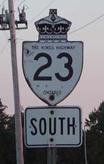
King's Highway 89 |
|
|
|
Highway 23 was downloaded East of
Highway 89 in 1998. Its new names are
Perth Road 93 and Wellington Road 123.
Pre-1998 Routing Shown Below. |
| North Perth - Minto Boundary |
Palmerston |
--- |
Perth Line 91 (Perth Road 91) |
| Town of Minto |
Palmerston |
--- |
Wellington Road 5 |
| North Perth - Minto Boundary |
Teviodale |
--- |
Perth Road 140 |
| North Perth - Minto Boundary |
Teviodale |
96.9 km / 0 km |
Highway 9 (Wellington Road 109) & Wellington
Road 7 |
|
|
|
In 2004 Highway 23 was rerouted
on a former portion of Highway 89 towards Harriston. Detailed Route
Information shown below: |
|
Just West of Palmerston:
NB: Turn Left towards Harriston on Old 89. SB: Ramp Right on SB 23
towards Listowel. |
|
North Perth - Minto Boundary |
----- |
88.0 km / 9.7 km |
Perth Road 93/Wellington Road 123 (Old Highway 23) |
|
At Highway 87 (Wellington Road
87) Junction: NB: Ramp Right towards Harriston. SB: Turn Left
towards Palmerston and Listowel |
|
Town of Minto |
----- |
96.1 km / 1.6 km |
Highway 87 (Wellington Road 87) |
|
Town of Minto |
Harriston |
97.7 km / 0 km |
King's Highway 9/Wellington Road 109 &
King's Highway 89 |
|
Highway 23 ENDS |