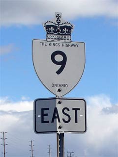
|
Proper Municipality Name |
Community Name |
Distance |
Intersecting Road |
| Municipality of Kincardine |
----- |
0km / 191.8km |
King's Highway 21 |
| Municipality of Kincardine |
Millarton |
--- |
----- |
| Municipality of Kincardine |
----- |
8.0km / 183.8km |
Bruce Road 7 |
| Municipality of Kincardine |
Bervie |
--- |
----- |
| Township of Huron-Kinloss |
Kinloss |
17.7km / 174.1.1km |
Bruce Road 1-South |
| Township of Huron-Kinloss |
Kinloss |
18.0km / 173.8km |
Bruce Road 1-North |
| Municipality Brockton |
Riversdale |
--- |
----- |
| Municipality Brockton |
----- |
26.6km / 165.2km |
Highway 4-South (Bruce Road 4) & Bruce Road 20 |
| Municipality Brockton |
Greenock |
--- |
----- |
| Municipality Brockton |
----- |
33.8 km / 158.0 km |
Bruce Road 12 |
| Municipality Brockton |
----- |
35.9 km / 155.9 km |
Bruce Road 3 |
|
Heading East take the ramp to the
right to remain on Highway 9 at Yonge Street. Towards Kincardine: to
stay on Highway 9 you must turn left away from downtown Walkerton |
| Municipality Brockton |
Walkerton |
40.0 km / 151.8 km |
Highway 4-East (Yonge Street) |
| Municipality of South Bruce |
Otter Creek |
--- |
----- |
| Municipality of South Bruce |
----- |
46.6 km / 145.2 km |
Bruce Road 16 |
|
Municipality of South Bruce |
(Former) Mildmay North
Limits |
48.1km / 143.7km |
----- |
| Municipality of South Bruce |
Mildmay |
48.4 km / 143.4 km |
Bruce Road 3 |
| Municipality of South Bruce |
Mildmay |
48.7km / 143.1km |
Absalom Street
(Bruce Road 24) |
|
Municipality of South Bruce |
(Former) Mildmay South
Limits |
49.2km / 142.6km |
----- |
|
Horwick - Minto Boundary |
----- |
61.3 km / 130.5 km |
Huron Road 35 / Wellington Road 1 |
|
Town of Minto |
(Former) Clifford West
Limits |
61.4km / 130.4km |
----- |
| Town of Minto |
Clifford |
62.2 km / 129.6 km |
Allen Street (Wellington Road 2-West) |
|
Town of Minto |
Clifford |
62.7km / 129.1km |
Mill Street (Wellington Road 2-East) |
|
Town of Minto |
(Former) Clifford East
Limits |
63.0km / 128.8km |
----- |
| Town of Minto |
Harriston Junction |
--- |
----- |
|
Town of Minto |
(Former) Harriston West
Limits |
72.1km / 119.7km |
----- |
| Town of Minto |
Harriston |
72.8 km / 117.0 km |
King's Highway 23 &
King's Highway 89 |
|
Current Eastern Terminus of the
Western Segment of Highway 8 is located at the Highway 23/89 junction in
Harriston. East of Harriston Highway 9 is know as Wellinton Road 109 |
|
Town of Minto |
(Former) Harrison East
Limits |
--- (74.2km) / --- (117.6km) |
----- |
| Town of Minto |
----- |
--- (75.0km) / --- (116.8km) |
Wellington Road 5 |
| Town of Minto |
Cotswold |
--- |
----- |
|
EB: Turn Left at Teviotdale. WB: Take
the ramp to the right at Teviodale. |
| Minto - Mapleton Boundary |
Teviotdale |
--- (84.9km) / --- (106.9km) |
Highway 23 (Wellington Road 123 / Perth Road 93)
& Wellington Road 7 |
|
Mapleton - Wellington North Boundary |
----- |
--- (86.1km) / --- (105.7km) |
Wellington Road 6 |
|
Mapleton - Wellington North Boundary |
----- |
--- (90.8km) / --- (101.0km) |
Wellington Road 10 |
|
Mapleton - Wellington North Boundary |
----- |
--- (96.9km) / --- (94.9km) |
Wellington Road 11 |
|
Mapleton - Wellington North Boundary |
----- |
--- (103.1km) / --- (88.7km) |
Wellington Road 12 |
|
Mapleton - Wellington North Boundary |
----- |
--- (103.2km) / --- (88.6km) |
King's Highway 6 |
|
Wellington North - Centre Wellington Boundary |
----- |
--- (108.7km) / --- (83.1km) |
Wellington Road 16 |
|
Wellington - Dufferin Boundary.
Both Wellington and Dufferin have designated Highway 9 as County Road 109 |
|
East Luther Grand Valley - East Garafraxa Boundary |
----- |
--- (121.4km) / --- (70.4km) |
Belwood Road (Dufferin Road 5) |
|
East Luther Grand Valley - East Garafraxa Boundary |
----- |
--- (121.7km) / --- (70.1km) |
Highway 25-North (Dufferin Road 25) |
|
East Luther Grand Valley - East Garafraxa Boundary |
----- |
--- (124.1km) / --- (67.7km) |
Dufferin Road 6 |
|
East Garafraxa - Amaranth Boundary |
----- |
--- (124.5km) / --- (67.3km) |
Highway 25-South (Dufferin Road 24). |
|
East Garafraxa - Amaranth Boundary |
----- |
--- (131.1km) / --- (60.7km) |
Dufferin Road 12 |
|
East Garafraxa - Amaranth Boundary |
----- |
--- |
Third Line Road (Dufferin Road 11) |
|
East Garafraxa - Amaranth - Orangeville Boundary |
----- |
--- (135.4km) / --- (56.4km) |
Orangeville - Fergus Road (Dufferin Road 3) |
|
Amaranth - Orangeville Boundary |
Orangeville West Limtis |
--- (136.7km) / --- (55.1km) |
Dufferin Road 16 |
|
In the Town of Orangeville
Highway 9 is known only as Broadway |
|
Town of Orangeville |
Orangeville |
--- (139.3km) / --- (52.5km) |
Highway 136 (John Street) |
|
Town of Orangeville |
Orangeville |
--- (139.5km) / --- (52.3km) |
First Street |
|
EB: Take the ramp to
Southbound Highway 10. WB: Turn Left at Broadway Street |
|
Town of Orangeville |
Orangeville |
--- (140.7km) / --- (51.1km) |
King's Highway 10-North/Highway
24-North |
|
EB: Turn Left at Highway 9
East (Newmarket). WB: Take the ramp to Highway 10 Northbound. |
|
Western Terminus of eastern
segment of Highway 9 is located at Highway 10 |
|
Town of Orangeville |
Orangeville |
141.2km / 50.6 km |
King's Highway 10-South/Highway
24-South |
|
Caledon - Mono Boundary |
Tamarack |
--- |
----- |
|
Caledon - Mono Boundary |
Mono Mills |
150.5 km / 41.3km |
Airport Road (Peel Road 7 / Dufferin Road 18) |
|
Caledon - Tosorontio Boundary |
----- |
155.0km / 36.8km |
The Gore Road (Peel Road 8) |
|
Caledon - Tosorontio Boundary |
----- |
159.5km / 32.3km |
Highway 50 (Peel Road 50 / Simcoe Road 50) |
|
Caledon - New Tecumseth Boundary |
Black Horse |
--- |
----- |
|
Caledon - New Tecumseth Boundary |
----- |
165.2km / 26.6km |
Simcoe Road 10 |
|
Caledon - New Tecumseth Boundary |
Tecumseth Pines |
--- |
----- |
|
New Tecumseth - King Boundary |
Schomberg |
175.1km / 16.7km |
Highway 27 (York Road 27 / Simcoe Road 27) |
|
New Tecumseth - King Boundary |
----- |
179.7 km / 12.1km |
Canal Road (Simcoe Road 8) |
|
Township of King |
----- |
181.3km / 10.5km |
Weston Road (York Road 56) |
|
Township of King |
----- |
182.2 km / 9.6 km |
King's Highway 400 |
|
Current Eastern terminus of
Highway 9 is located at Jane Street (just east of Highway 400) |
|
Township of King |
----- |
--- (8.4km) / --- (183.4km) |
Jane Street (York Road 55) |
|
Township of King |
Glenville |
--- |
----- |
|
King - Newmarket Boundary |
----- |
--- (2.2km) / --- (189.6km) |
Bathurst Street
(York Road 38 |
|
Town of Newmarket |
Newmarket |
--- (191. 8km) / --- (0km) |
Highway 11 (Yonge Street, York Road 1) |
|
Highway 9 ENDS |