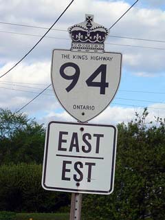
King's Highway
94 - www.OntHighways.com
King's Highway 94 serves as the
major highway connection to Corbeil. It also serves as a shortcut route
between Highways 11 and 17-East. 94 is a short highway, and was
totally untouched by the provincial highway downloading that took place in
1997/98.

Old Style King's Highway 94 Shield
|
|
Southern Terminus: Junction Secondary
Highway 654 just west of Highway 11. Northern Terminus: Highway 94 ends at
the Highway 17 junction just north of Corbeil
Length: 12.4 km
Multiplexes: None
Freeway: No
AADT (2002): Highest:
4.150, from Highway 654 to Main Street (the start of the Callander Bay
Bypass);
Lowest: 2,950 from Astorville Road to Highway 17.
Road Info: Highway 94 is a short
highway with light traffic volumes. Road condition is generally quite
good along the highway, as much of the highway was reconstructed in the fall
of 2006. Rural speed limits along Highway 94 are posted at 80km/h. |
Communities and Major Intersections along Highway 94 from South to North:
|
Proper Municipality Name |
Community Name |
Distance |
Intersection Road |
|
Township of North Himsworth |
----- |
0 km / 12.4 km |
Secondary Highway 654 (Nosbonsing Road) |
|
Township of North Himsworth |
----- |
1.6 km / 10.9 km |
Main Street |
|
NB: Turn Right at Lansdowne
Street towards Corbeil. SB: Turn left away from Callander towards
Highway 654. |
|
Township of North Himsworth |
----- |
3.1 km / 9.3 km |
Lansdowne Street & Callander Bay Drive (north) |
|
Township of East Ferris |
Corbeil |
10.3 km / 2.1 km |
Astorville Road |
|
Township of East Ferris |
----- |
12.4 km / 0 km |
King's Highway 17 |
|
Highway 94 ENDS |
<- Highway
93 www.OntHighways.com - Home
Highway 95 ->
Copyright (c) 2004-2010, AsphaltPlanet.ca
AsphaltPlanet@asphaltplanet.ca
Page last updated: December 21st, 2004
Page created: December 19th, 2004
