Secondary Highway 509 - www.OntHighways.com

Highway 509 was a local highway that serves a number of small communities along the historic Snow and Lavant Colonization Roads.  Highway 509 was transferred to local municipalities within the County of Frontenac on January 1st, 1998.


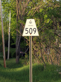
Secondary Highway 509 Shield

  Southern Terminus:  Junction Highway 7 west of Sharbot Lake.

Northern Terminus:  Transition to Highway 506 at Plevna.

Length:  52.6 km

Multiplexes:  None

Orientation: North-South and East-West

Regions Served: Frontenac County

AADT (1994):  Highest:  650, from Highway 7 northerly to Clarendon Station;

                             Lowest:  250, from Clarendon Station northerly to the Snow Road junction.

Status:  Totally downloaded.  Highway 509 is now known as Road 509.

Road Info:  Highway 509 is in reasonable shape for its entire length.  The highway is paved, and has a yellow centre line for its entire length.


Highway 509 information:


OntHighways.com  

Detailed Route information available below
Virtual Tour of Highway 509

Communities and Intersections along and Highway 607 from South to North:

Proper Municipality Name Community Name Distance Intersecting Road
Township of Central Frontenac ----- --- (0km) / --- (52.6km) King's Highway 7
Township of Central Frontenac Clarendon Station --- (10.0km) / --- (42.6km) -----
Township of North Frontenac Mississippi Station --- -----
Township of North Frontenac Snow Road Station --- Snow Road (to Lanark Road 36)
Township of North Frontenac Donaldson --- -----
Township of North Frontenac ----- --- Lavant Road (to Lanark Road 16)
Township of North Frontenac Ompah --- -----
Township of North Frontenac Plevna --- (52.6km) / --- (0km) Highway 506 & Buckshot and Sand Lake Road (to Lennox & Addington Road 30).
Highway 509 Ends

<- Highway 508          www.OntHighways.com - Home          Highway 510 ->


Copyright (c) 2004-2012, Scott Steeves (Webmaster)  scott@asphaltplanet.ca

Page last updated:  April 23rd, 2012

Page created:  April 23rd, 2012