|
|
|
|
|
|
South-
Bound
|
|
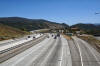
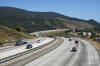
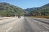
Los Angeles County
|
Two views looking southerly from the Vista Del Lago Road overpass.
Pyramid Lake lies just to the west (right) of Interstate 5. |
 |
|
High-res:
(1440x960)
(2400x1600) |
 |
|
Photographed by: AsphaltPlanet.ca |
Date: 3/27/2010 |
High-res:
(1440x960)
(2400x1600) |
|
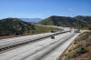
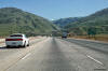
Los Angeles County
|
View looking northerly from the Vista Del Lago Road overpass. |
 |
|
Photographed by: AsphaltPlanet.ca |
Date: 3/27/2010 |
High-res:
(1440x960)
(2400x1600) |
|
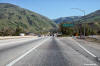
Kern County
|
Southbound signage for the interchange to the community of Grapevine.
Interstate 5 can be seen snaking through the mountain range just beyond
the photo. |
 |
|
Photographed by: AsphaltPlanet.ca |
Date: 4/16/2017 |
High-res:
(1440x960)
(2400x1600) |
|
Kern County
|
Second of three signs for the southbound off-ramp to Grapevine. |
 |
|
Photographed by: AsphaltPlanet.ca |
Date: 4/16/2017 |
High-res:
(1440x960)
(2400x1600) |
|
Kern County
|
Southbound signage 1 mile upstream from the Grapevine interchange. |
 |
|
Photographed by: AsphaltPlanet.ca |
Date: 4/12/2017 |
High-res:
(1440x960)
(2400x1600) |
|
State Route 99 begins north of the Grapevine, and
heads northerly through the heart of the Central Valley.
Click here for Highway
99 Images. |