King's Highway 35B - www.OntHighways.com

Highway 35B is a short business route through Lindsay.  It was downloaded in 1997, but is almost entirely still signed.


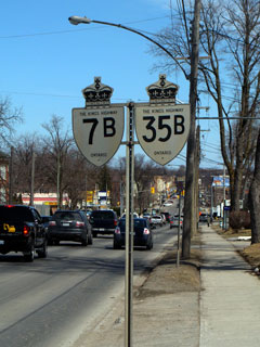
King's Highway 35B Shield

  Eastern Terminus:  Junction Highway 7 and 35 at the south end of the Lindsay Bypass

Western Terminus:  Junction Highway 35 in the west end of Lindsay.  Highway 7B continues further to the west of Highway 35 junction to Highway 7.

Length:  5.8km

Multiplexes:  Highway 35B shares its routing with Highway 7B for its entire length.

Freeway: No

Status:  Totally downloaded in 1997.  Now known as the Kent Street, Lindsay Street, and Kawartha Lakes Road 15.

Road Info:  Highway 35B is in reasonable condition for its entire length.  Its a four lane road from the Historic Downtown core westerly to Highway 35 and 7 along Kent Street.  For this stretch the highway is an excellent stopping point for tourists and travelers.  Any service or popular fast food restaurant one could desire can be found along Kent Street.  Lindsay Street from the Downtown Core southerly is far more residential and is not lined with commercial services.


Highway 35B information:


OntHighways.com  

Detailed Route information available below
Virtual Tour of Highway 35B


TheKingsHighway.ca   History of Highway 35B
Photographic History of Highway 35B


Proper Municipality Name Community Name Distance Intersection Name
City of Kawartha Lakes ----- 0km / 5.8km King's Highway 35-North
City of Kawartha Lakes Lindsay --- Angeline Street (Kawartha Lakes Road 4)

At the Kent Street/Lindsay Street junction.  EB: Turn Right.  WB: Turn Left.

City of Kawartha Lakes Lindsay 4.5km / 1.3km Highway 36B (Lindsay Street-North)
City of Kawartha Lakes ----- 5.8km / 0km King's Highway 7-East/35-South

Highway 35B ENDS


<- Highway 35         www.OntHighways.com - Home         Highway 36 ->


Copyright (c) 2004-2009, AsphaltPlanet.ca  webmaster@onthighways.com

Page last updated:  April 18th, 2009

Page created:  April 18th, 2009