King's Highway 7B (Peterborough) - www.OntHighways.com

Highway 7B was a long business route connecting Highway 7 at Fowlers Corners to Highway 7 at the east end of the 115 through Peterborough.  The entire route of Highway 7B was downloaded in 1998, with all signage removed.  While the province probably didn't need to maintain any segment of Highway 7B as they had prior to 1998, Peterborough is a confusing city to drive through and benefited from a route numbering system.


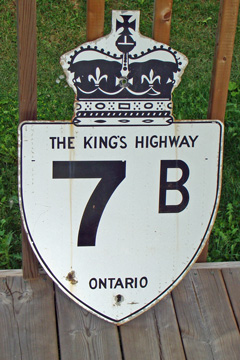
Old style King's Highway 7B shield.

 
Western Terminus:  Junction Highway 7 in Fowler's Corner.

Eastern Terminus:  Junction Highway 7/115 in eastern Peterborough.

Length:  19.5km

Multiplexes:  None

Freeway: No

AADT (1994):  Highest: 13,150, from Peterborough northerly to Chemong Road;

                             Lowest: 4,850 from Fowlers Corners easterly to Chemong Road.

Status:  Entirely downloaded:  New names are Peterborough Road 1, Chemong Road, Parkhill Road, Monaghan Road, and Lansdowne Street.

Road Condition:  Highway 7B is in good condition for its entire length.  The western leg of the highway is rural, however much of the highway is urban where it passes through the City of Peterborough.  All road signs pertaining to Highway 7B have been removed through Peterborough, it is therefore impossible to follow the old route of the highway without consulting an older map (or this website).  Speed limits along Highway 7B (Peterborough) vary between 50km/h and 80km/h.


Highway 7B (Peterborough) information:


OntHighways.com  

Detailed Route information available below
Virtual Tour of Highway 7B (Peterborough)


TheKingsHighway.ca   History of Highway 7B (Peterborough)
Photographic History of Highway 7B (Peterborough)

Communities and Major Intersections along Highway 7B from West to East:

Proper Municipality Name Community Name Distance Intersecting Road
East of Fowlers Corners Highway 7B has been designated Peterborough Road 1.
Township of Smith - Ennismore - Lakefield Fowlers Corners 0km / 19.5km King's Highway 7 & Kawartha Lakes Road 28
Township of Smith - Ennismore - Lakefield ----- 3.7km / 15.8km Fife's Bay Road (Peterborough Road 12)

At Chemong Road:  EB: Follow the ramp to the right to head south.  WB: Turn left onto Peterborough Road 1 towards Lindsay

Township of Smith - Ennismore - Lakefield ----- 7.0km / 12.5km Chemong Road (North) (Peterborough Road 18)
Township of Smith - Ennismore - Lakefield ----- 8.9km / 10.6km Towerhill Road (Peterborough Road 19)

At Parkhill Road East:  EB: Turn Right onto Parkhill Road.  WB: Turn left onto Chemong Road

City of Peterborough Peterborough 11.8km / 7.7km Parkhill Road (East) (Formerly Highway 28-North)
City of Peterborough Peterborough --- Fairbairn Street

At Parkhill Road West:  EB: Turn left onto Monaghan Road.  EB: Turn Right onto Parkhill Road

City of Peterborough Peterborough --- Parkhill Road (West)
City of Peterborough Peterborough 15.6km / 3.9km Charlotte Street (Formerly Highway 28-South)
City of Peterborough Peterborough --- Sherbrooke Street

At Lansdowne Street:  EB: Turn left onto Lansdowne Street.  WB: Turn Right onto Monaghan Road.

City of Peterborough Peterborough --- Lansdowne Street (West) & Monaghan Road (South)
City of Peterborough Peterborough --- George Street
City of Peterborough Peterborough --- Asburnham Road
City of Peterborough Peterborough 19.5km / 0km King's Highway 7/115
Highway 7B ENDS

<-Highway 7B (Lindsay)          www.OntHighways.com - Home          Highway 7B (Carleton Place) ->


Copyright (c) 2004-2012, AsphaltPlanet.ca  AsphaltPlanet@asphaltplanet.ca
Page last updated:  XXX, 2012

Page created:  XXX, 2012