AsphaltPlanet.ca >
OntHighways > Highway 132> Images
< Hwy 131
Hwy 133 >
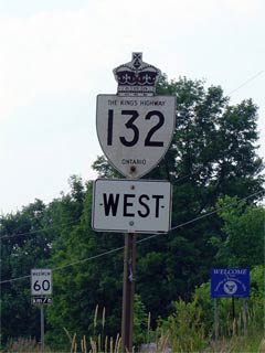
King's Highway
132 - www.OntHighways.com
Highway 132
runs between Highway 41 at Dacre easterly through the Opeongo Hills to Highway
60 at Renfrew. No portion of Highway 132 was downloaded in either the 1997 or 1998
provincial highway downloading sprees.
Old Style
King's Highway 132 Shield
|
|
Western Terminus: Junction Highway
41 west of Dacre
Eastern Terminus: Junction Highway
60 in Downtown Renfrew
Length: 29.9km
Multiplexes: None
Freeway: No
AADT (2002): Highest: 2,650,
from Renfrew Road 5 easterly to Renfrew;
Lowest: 1,450, from Highway 41 easterly to Renfrew Road 5.
Road info: Highway 132 is fairly
lightly traveled and is built to an older standard then most modern king's
highways. Highway 132 passes through a fairly rugged portion of
Eastern Ontario, and as such winds through numerous hills and valleys.
Highway 132 has a rural posted speed limit of 80km/h. |
Communities and Major Intersections located along Highway 132 from West to East:
|
Proper Municipality Name |
Community Name |
Distance |
Intersecting Road |
| Municipality of Bonnechere Valley |
----- |
0km / 29.9km |
King's Highway 41 |
| Municipality of Bonnechere Valley |
Dacre |
2.5km / 27.4km |
Highway 513 (Scotch Bush Road) |
| Township of Greater Madawaska |
Lower Dacre |
--- |
----- |
| Township of Admaston Bromley |
Shamrock |
--- |
----- |
| Township of Admaston Bromley |
----- |
18.0km / 11.9km |
Whelan Road (Renfrew Road 34) |
| Township of Admaston Bromley |
----- |
24.3km / 5.6km |
Stone Road (Renfrew Road 5) |
| Township of Admaston Bromley |
Renfrew Junction |
--- |
----- |
| Admaston Bromley - Renfrew Boundary |
Renfrew West Limits |
28.1km / 1.8km |
----- |
|
At Lochiel Street: EB: Turn
Right onto Lochiel Street, followed by a left turn onto Monroe Street.
WB: Turn Right onto Lochiel Street and left onto Lisgar Street |
| Town of Renfrew |
Renfrew |
29.9km / 0km |
King's Highway 60 |
|
Highway 132 ENDS |
<- Highway
131 www.OntHighways.com - Home
Highway 133 ->
Copyright (c) 2004-2011, AsphaltPlanet.ca
AsphaltPlanet@asphaltplanet.ca
Page last updated: October 19th,
2006
Page created: October 19th, 2006