AsphaltPlanet.ca >
OntHighways > Highway 427 >
Images
< Hwy 420
Hwy 502 >
King's Highway
427 - www.OntHighways.com
Highway 427 is a short commuter
highway that runs along the west side of Etobicoke in the city of Toronto.
Despite its short length, Highway 427 is part of Canada's national highway
network, and is Ontario's second busiest highway.
Highway 427 exists in two distict phases. The
portion south of Highway 401 replaces a former alignment of Highway 27 that was
upgraded to expressway standards in the 1950s. The section to the north of
Highway 401 was first constructed as an access road to Toronto's Pearson
(Malton) Airport as a 7000-series highway (Highway 7010) between Highway 401 and
Dixon Road. Highway 7010 was known as the Airport Expressway at that time.
In 1972, the Highway 427 designation was applied to both Highway 27 from the QEW
to Highway 401 and the Airport Expressway. Over the decades that preceded
from 1972 until now, Highway 427 was gradually extended northerly from Pearson
Airport, first to Indian Line, north of Finch Avenue, then to Highway 7 as a
precursor to the completion of the 407, and then most recently in 2021 to Major
Mackenzie Drive in Vaughan.
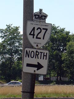
King's Highway 427 Shield
|
|
Southern Terminus: At Coules Court
(just south of the QEW) in Etobicoke.
Northern Terminus: Major Mackenzie
Drive in Vaughan.
Length: pre-2021: 21.3 km
Multiplexes: None
Freeway: Entire Length
AADT (2002):
Highest: 317,400, from Burnhamthorpe Road northerly to Rathburn Road in
Etobicoke;
Lowest: 46,500, from Evans Avenue northerly to the QEW.
Road Info: Like most other
Ontario freeways, the 427 is in good shape for its entire length. From
the QEW northerly to Highway 401, the 427 is a twelve-lane freeway with a
core-distributor system. This section of the 427 is very unique, since
the highway hasn't been changed since it was reconstructed into a
twelve-lane freeway in the mid-1970s. North of the 401, Highway 427
has between a 4- and 10-lane cross-section and has a much more suburban
appearance compared to the very urban southern section. |
Interchanges along Highway 427 from South to North:
|
Proper
Municipality Name |
Distance |
Interchange
Name |
North / West Control City |
South / East Control City |
| City of Toronto |
0 km / 21.3 km |
Coules Court & Browns Line South - At Grade |
|
|
| City of Toronto |
0.2 km / 21.1 km |
Evans Avenue |
|
|
| City of Toronto |
0.7 km / 20.5 km |
Queen Elizabeth Way / Gardiner Expressway |
Toronto Downtown |
Hamilton |
| City of Toronto |
1.0 km / 20.3 km |
The Queensway - North Partial Interchange |
|
|
| City of Toronto |
2.6 km / 20.3 km |
Highway 5 (Dundas Street) |
|
|
| City of Toronto |
4.5 km / 16.8 km |
Burnhamthorpe Road |
|
|
| City of Toronto |
5.6 km / 15.7 km |
Rathburn Road - South Partial Interchange |
|
|
| City of Toronto |
7.2 km / 14.1 km |
King's Highway 27
- South Partial Interchange |
|
|
| City of Toronto |
8.2 km / 13.1 km |
King's Highway 401 |
|
|
| Toronto - Mississauga Boundary |
11.2 km / 10.1 km |
Dixon Road - South Partial Interchange |
Pearson International Airport |
|
| Toronto - Mississauga Boundary |
12.3 km / 8.6 km |
King's Highway 409 |
Pearson International Airport |
|
| Toronto - Mississauga Boundary |
15.2 km / 6.1 km |
Rexdale Boulevard & Derry Road (Peel Road 5) |
|
|
| City of Toronto |
17.1 km / 4.2 km |
Finch Avenue |
|
|
| City of Vaughan |
19.4 km / 1.8 km |
Highway 407 ETR |
----- |
----- |
| City of Vaughan |
21.3 km / 0 km |
Highway 7 (York Road 7) |
|
|
|
Highway 427 ENDS |
<- Highway 420
www.OntHighways.com - Home
Highway 502 ->
Copyright (c) 2004-2010, AsphaltPlanet.ca
AsphaltPlanet@asphaltplanet.ca
Page last updated: March 28th, 2005
Page created: March 28th, 2005