|
Proper Municipality Name |
Community Name |
Distance |
Intersecting Road |
|
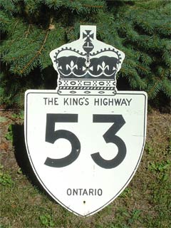
Highway 53 has been designated as
Oxford Road 55 in Oxford County. |
| Township of Blandford- Blenheim |
Eastwood |
--- (0km) / --- (76.4km) |
Highway 2 (Oxford Road 2) |
| Township of Blandford- Blenheim |
----- |
--- |
Towerline Road (Oxford Road 15) |
| Township of Blandford- Blenheim |
----- |
--- |
King's Highway 403 |
|
Oxford - Brant Boundary:
EB: Highway 53 is known as Brant Highway 53. WB: Highway 53 has been
designated as Oxford Road 55 |
| Blandford- Blenheim (Oxford) - Brant County Boundary |
Muir - Brant County West Limits |
--- (6.8km) / --- (69.6km) |
Muir Road (Oxford Road 22 / Brant Road 130) |
| City of Brant County |
Cathcart |
--- |
----- |
| City of Brant County |
----- |
--- (14.8km) / --- (61.6km) |
Middletown Line (Brant Road 25) |
| City of Brant County |
----- |
--- |
Harley Road (Brant Road 202) |
| City of Brant County |
(Former) Burford West Limits |
--- (19.3km) / --- (57.1km) |
----- |
| City of Brant County |
Burford |
--- (21.4km) / --- (55.0km) |
John Street |
| City of Brant County |
Bishopsgate |
--- |
Bishop Gate Road (Brant Road 16) |
| City of Brant County |
Mount Vernon |
--- |
----- |
| City of Brant County |
----- |
---(26.4km) / --- (50.0km) |
King's Highway 24 (Pre-1997,
Highway 24-South, Rest Acres Road North) |
| City of Brant County |
----- |
--- |
Pleasant Ridge Road (Brant Road 7) |
|
Brant County - Brantford
Boundary: EB: Highway 53 is known as Colborne Street in Brantford.
WB: Highway 53 is known as Brant Highway 53. |
| Brant County - Brantford Boundary |
Brantford West Limits |
--- (30.9km) / --- (45.5km) |
----- |
|
At the Brantford Southern Access
Road: EB: Turn Left to follow Colborne Street. WB: Turn Right
following Colborne Street |
| City of Brantford |
Brantford |
--- |
Brantford Southern Access Road |
| City of Brantford |
Brantford |
--- |
Mount Pleasant Street |
|
At
Brant Ave. EB: Continue easterly along
Colborne Street. WB: Turn Left on Brant Avenue, and take first right
onto Colborne Street. |
| City of Brantford |
Brantford |
--- (34.1km) / --- (42.3km) |
Highway 2-West, Pre-1997 Highway 24-North (Brant
Avenue) & Icomm Drive |
| City of Brantford |
Brantford |
--- |
Clarence Street |
|
EB: One Way End: EB and Westbound traffic follow
Colborne Street. WB: Start of divided road, westbound traffic follows
Dalhousie Street. |
| City of Brantford |
Brantford |
--- |
Wayne Gretzky Parkway |
| Brantford - Brant County Boundary |
Brantford East Limits |
--- |
----- |
| City of Brant County |
Cainsville |
--- (40.4km) / --- (36.0km) |
Brant Road 18 (Highway 54-S) |
| City of Brant County |
----- |
--- (42.1km) / --- (34.4km) |
Jerseyville Road (Brant Road 17) |
| City of Brant County |
Langford |
--- |
----- |
| City of Brant County |
----- |
--- (47.1km) / --- (29.3km) |
White Swan Road (Brant Road 8) |
|
Brant - Hamilton Boundary:
EB: Highway 53 is known as Wilson Street in Western Hamilton. WB:
Highway 53 is known as Brant Highway 53. |
| Brant County - Hamilton Boundary |
Brant - Hamilton Limits |
--- (48.8km) / --- (28.0km |
----- |
| City of Hamilton |
----- |
--- (48.8km) / --- (27.6km) |
Sunnyridge Road (Formerly H-W Road 203) |
| City of Hamilton |
Alberton |
--- |
----- |
| City of Hamilton |
----- |
--- (53.6km) / --- (22.8km) |
Highway 52 (Hamilton Road 52) &
Trinity Road (Hamilton Road
65) |
|
At Duff's Corners: EB: Follow the ramp to the right
following Garner Road. WB: Turn Left at traffic lights onto Wilson
Street |
| City of Hamilton |
Duff's Corners |
--- (55.2km) / --- (21.2km) |
Highway 2-East (Wilson Street) |
| City of Hamilton |
----- |
--- |
Fiddlers Green Road (Formerly H-W Road 16) |
| City of Hamilton |
----- |
--- |
King's Highway 6-NB
Only & King's Highway 403-EB Only |
| City of Hamilton |
----- |
--- |
Southcote Road (Formerly H-W Road 248) |
|
At Glancaster Road: EB: Highway 53 is known as Rymal
Road. WB: Highway 53 is known as Garner Road west of Glancaster Road |
| City of Hamilton |
(Former Hamilton West Limits) |
--- (63.4km) / --- (13km) |
Glancaster Road |
| City of Hamilton |
Hamilton |
--- |
Garth Street |
| City of Hamilton |
Ryckman's Corners (Hamilton) |
--- |
Upper James Street (Pre-2004 Highway 6) |
| City of Hamilton |
Hamilton |
--- |
Upper Wellington Street |
| City of Hamilton |
Hamilton |
--- |
Upper Wentworth Street |
| City of Hamilton |
Hamilton |
--- |
Upper Sherman Avenue |
| City of Hamilton |
Hamilton |
--- |
Upper Gage Avenue |
| City of Hamilton |
Hamilton |
--- |
Upper Ottawa Street |
| City of Hamilton |
(Hannon) Hamilton |
--- |
Dartnall Road |
| City of Hamilton |
(Former Hamilton East Limits) |
--- (72.7km) / --- (3.7km) |
Trinity Church Road |
| City of Hamilton |
----- |
--- |
Fletcher Road |
| City of Hamilton |
Elfrida |
--- (76.4km) / --- (0km) |
Highway 20 (Upper Centennial Parkway,
Hamilton Road 20) & Highway 56 (Hamilton
Road 56) |
|
Highway 53 ENDS |