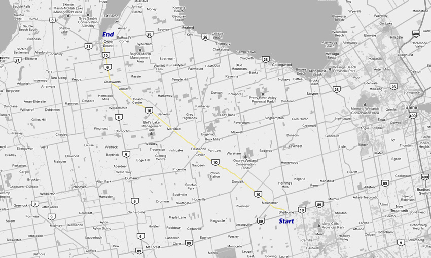
King's Highway 10 - Images
<- Page 2 Page 3 - Shelburne to Owen Sound
| Proper Municipality Name | Photo Description | Photo | |
|
Pictures taken from driver's perspective appear offset from centre-line pictures: |
North- Bound |
South- Bound |
|
| Continued from Brampton to Shelburne Images | |||
| Highway 89 leads west from Shelburne bound for Mount Forest and Harriston. Click here for Highway 89-West images. | |||
| Town of Shelburne County of Dufferin |
Southbound junction assembly at the Highway
89-West junction in Shelburne. Obviously, a left turn is required to
proceed southerly along Highway 10 (and to avoid driving into the sports
store). Photo taken: February 11th, 2010. |
 |
|
| Town of Shelburne County of Dufferin |
View looking southerly as Highway 10 approaches
the four-corners of Shelburne. Shelburne is a pleasant midwestern
Ontario small town that has done well to attract travelers bound from the
GTA to Owen Sound and Collingwood. Photo taken: February 11th, 2010. |
 |
|
| Township of Melancton County of Dufferin |
View looking northerly into a hazy afternoon sky
towards the Dufferin Road 17 intersection. Photo taken: May 20th, 2011. |
 |
|
| Township of Melancton County of Dufferin |
Southerly view along Highway 10 approaching the
250 Road intersection. Highway 10 is very flat and nearly perfectly straight
between Dundalk and Shelburne. It is quite easy to eat up the miles quickly
along this particular stretch of Highway 10. Photo taken: May 20th, 2011. |
 |
|
| Melancton / Southgate Boundary Dufferin / Grey Boundary |
View looking southerly from the County Road 9
intersection in Dundalk. Note the wind-farm that dots the landscape,
collectively they are known as the Melancton wind farm; it is Ontario's
largest wind-farm by both the number of turbines on the site, and by the
number of kilowatts generated. Photo taken: February 11th, 2010. |
 |
|
| Municipality of Grey Highlands County of Grey |
View looking southerly as Highway 10 leaves
Flesherton. Toronto is the southbound control city along Highway 10.
Most highways that point towards the Greater Toronto area use Toronto as a
control city, despite the fact that the highway may not actually pass with
Toronto's City limits. Photo taken: February 11th, 2010. |
 |
|
| Highway 4 is a long highway that lead from Port Stanley on Lake Erie, to Highway 24 south of Collingwood. Click here for Highway 4 images. | |||
| Grey Highlands / West Grey
Boundary County of Grey |
This view looks southerly approaching the Road
10 intersection south of Markdale. Photo taken: May 20th, 2011. |
 |
|
| Township of Chatsworth County of Grey |
Southerly view along Highway 10 looking south of
Berkeley. Photo taken: May 20th, 2011. |
 |
|
| Township of Chatsworth County of Grey |
View looking southerly as Highway 10 crosses
Hamilton Creek immediately south of Holland Centre. Photo taken: May 20th, 2011. |
 |
|
| Township of Chatsworth County of Grey |
Northerly view into a hazy afternoon sky towards
the Chatsworth Sideroad 20 intersection, from just north of Holland Centre. Photo taken: May 20th, 2011. |
 |
|
| Township of Chatsworth County of Grey |
Southerly view from just north of the Chatsworth
Sideroad 10. Highway 10 passes through numerous short valleys through
Chatsworth Township. Photo taken: May 20th, 2011. |
 |
|
| Township of Chatsworth County of Grey |
Early spring view of Highway 10 taken about a
kilometre south of the Grey Road 40 intersection. Photo taken: May 20th, 2011. |
 |
|
| Township of Chatsworth County of Grey |
Southerly view approaching the eastern leg of
Grey Road 40 south of Chatsworth. Just beyond (south) of the Grey Road
40 intersection, the southbound passing lane that is seen in the above photo
commences. Photo taken: May 20th, 2011. |
 |
|
| Township of Chatsworth County of Grey |
Historical site signage for a plaque for the
'Toronto-Sydenham Road'. The
historical plaque gives a brief synopsis of what the Toronto-Sydenham
Road is, its significance, and its routing. Photo taken: May 20th, 2011. |
 (720
x 540) (720
x 540)(1440x960) |
|
| Township of Chatsworth County of Grey |
Southbound distance signage leaving Chatsworth
along Highway 10. The southern control city for Highway 10 is Toronto,
despite the fact that Highway 10 terminates in Brampton. Photo taken: May 20th, 2011. |
 (720
x 540) (720
x 540)(1440x960) (2400x1600) |
|
| Township of Chatsworth County of Grey |
View looking northerly along Highway 10
approaching Chatsworth. Photo taken: May 20th, 2011. |
 |
|
| Township of Chatsworth County of Grey |
View looking northerly along Highway 10 (Toronto
& Sydenham Street) towards the
Highway 6
junction in Chatsworth. Despite serving almost an entirely provincial
purpose, there is a short connecting link agreement along Highway 10 south
from the
Highway 6
intersection. Photo taken: September 18th, 2005. |
 |
|
| Township of Chatsworth County of Grey |
Junction assembly for the junction of
Highway 6
and Highway 10 in Chatsworth. Highway 10 is multiplexed with
Highway 6 from Chatsworth to the
northern terminus of Highway 10 at Owen Sound. Photo taken: September 18th, 2005. |
||
| Highway 6 leads southerly towards Guelph, and eventually Hamilton and beyond. Click here for Highway 6-South images. | |||
| Township of Chatsworth County of Grey |
Southbound junction signage for the Highway 6/10 split. Photo taken: September 18th, 2005. |
 |
|
| Township of Chatsworth County of Grey |
Looking southerly into Chatsworth at the southern
intersection of Highway's 6 and 10. Photo taken: September 18th, 2005. |
 (720x480) (1440x960) |
|
| Georgian Bluffs - Meaford
Boundary County of Grey |
View looking south from the Grey Road 18 intersection. Photo taken: September 18th, 2005. |
 (720x480) (1440x960) |
|
| Georgian Bluffs - Meaford
Boundary County of Grey |
Southbound assembly for Highway 6/10. This multiplex is one of the
provinces oldest codesignations. Photo taken: September 18th, 2005. |
 |
|
| Georgian Bluffs - Meaford
Boundary County of Grey |
View looking northerly towards the Grey Road 18 intersection. Photo taken: September 18th, 2005. |
 (720x480) (1440x960) |
|
| Georgian Bluffs - Meaford
Boundary County of Grey |
Signage directing traffic bound north to Highway 6 north of Owen Sound onto
Grey Road 18. In the author's opinion, Grey Road 18 should be assumed
as Highway 6, with the current route through Downtown Owen Sound being
redesignated to Highway 6B. Photo taken: February 26th, 2004. |
 |
|
| Georgian Bluffs - Meaford
Boundary County of Grey |
Looking south towards the Grey County Road 18
intersection. Large channalized intersections such as this are quite
common on busy Ontario highways. Photo taken: May 20th, 2006. |
 (720x480) (1440x960) |
|
| Georgian Bluffs - Meaford
Boundary County of Grey |
Northerly view from the Grey County Road 18 intersection. Photo taken: May 20th, 2006. |
 (720x480) (1440x960) |
|
| Georgian Bluffs - Meaford
Boundary County of Grey |
Looking northerly about 1km south of Owen Sound's South Limits. Photo taken: May 20th, 2006. |
 (720x480) (1440x960) |
|
| City of Owen Sound |
View looking northerly into Owen Sound along Highway 6/10. Owen Sound
is a surprisingly busy community. Photo taken: May 20th, 2006. |
 (720x480) (1440x960) |
|
| City of Owen Sound |
Advanced signage for the Highway 21/26 junction. Photo taken: May 20th, 2006. |
 |
|
| City of Owen Sound |
Highway 10 ends at the Highway 21/26 junction. This is the only intersection in the province where 4-highways meet.
Photo taken: May 20th, 2006. |
 |
|
| Highway 10 ends in Owen Sound, just east of Downtown at Highways 6, 21, and 26. Click here for Highway 21 images and here for Highway 26 images.. | |||
<- Page 2 Images Highway 10 Images Index
<- Highway 9 Images Back to Highway 10 Highway 11 Images ->
Copyright (c) 2004-2012, Scott Steeves (Webmaster) AsphaltPlanet@asphaltplanet.ca