|
Proper
Municipality Name |
Community Name |
Distance |
Major
Intersection |
|
Pre downloaded version of
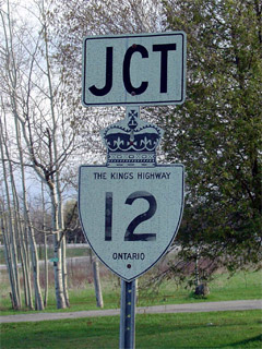
Highway 12: Now known as Brock Street in Whitby (still signed a s
King's Highway 12) |
| Town of Whitby |
Whitby |
0 km / 153.5 km |
King's Highway 401 |
| Town of Whitby |
Whitby |
--- |
Consumers Road (Durham Road 25) |
| Town of Whitby |
Whitby |
--- |
Highway 2 (Dundas Street) |
| Town of Whitby |
Whitby |
--- |
Manning Road (Durham Road 58) |
| Town of Whtiby |
Whitby |
--- |
Rossland Road (Durham Road 28) |
|
Pre downloaded version of Highway 12.
Known as Durham
Highway 12 north of Rossland Road to new southern terminus after 1998. |
| Town of Whitby |
Whitby |
5.6 km / 147.9 km |
Taunton Road (Durham Road 4) |
|
CURRENT (1998) SOUTHERN
TERMINUS OF HIGHWAY 12 |
|
Provincial Control begins from
about half way between Taunton Road and Highway 7-West at the proposed
Highway 407 alignment |
| Town of Whitby |
Brooklin |
10.3 km / 143.2 km |
King's Highway 7-West
& Winchester Road (Durham Road 3). |
| Town of Whitby |
----- |
14.5 km /
139.0 km |
Thickson Road (Durham Road 26) |
| Town of Whitby |
Myrtle |
16.7 km / 136.8 km |
Myrtle Road (Durham Road 5) |
| Town of Whitby |
Myrtle Station |
--- |
----- |
| Township of Scugog |
Manchester |
24.6 km / 128.9 km |
King's Highway 7A &
Durham Road 21 (Goodwood Road) |
| Township of Scugog |
----- |
27.7 km / 125.8
km |
Reach Street (Durham Road 8) |
| Township of Scugog |
----- |
31.9 km / 121.6
km |
Highway 47 (Durham
Highway 47) |
| Township of Scugog |
Greenbank |
--- |
----- |
| Township of Scugog |
Saintfield |
37.8 km / 115.7 km |
Saintfield Road (Durham Road 6) |
| Township of Brock |
----- |
42.4 km / 111.1
km |
Durham Road 13 |
| Township of Brock |
Blackwater |
--- |
----- |
| Township of Brock |
Sunderland |
47.1 km / 106.4 km |
River Street (Durham Road 10) |
| Township of Brock |
----- |
49.8 km /
103.7 km |
King's Highway 7-East. |
| Township of Brock |
Derryville |
--- |
----- |
| Township of Brock |
Creighton Corners |
55.8 km /
97.7 km |
Durham Road 12 |
| Township of Brock (Brock - Thorah) |
---- |
59.8 km /
93.7 km |
King's Highway 48-South |
| Township of Brock (Thorah |
(Beaverton By-Pass) |
65.9 km /
87.6 km |
Simcoe Street (Durham Road 15) |
| Township of Brock (Thorah) |
----- |
70.1 km /
83.4 km |
Mara Road (Durham Road 23) |
| Township of Brock (Thorah) |
---- |
72.7 km /
80.8 km |
Highway 48-East
(Durham Highway 48). |
| Township of Brock (Thorah) |
(Gamebridge By-Pass) |
--- |
Durham Road 50 |
| Township of Ramara |
----- |
--- |
Simcoe Road 47 |
| Township of Ramara |
Brechin |
80.3 km /
73.2 km |
----- |
| Township of Ramara |
----- |
83.0 km /
70.5 km |
Highway 169 (Simcoe Road 169) |
| Township of Ramara |
----- |
91.2 km / 62.3 km |
(Rama Road 46, Formerly
Simcoe County Road 46) |
| Township of Ramara |
Uptergrove |
--- |
----- |
| Township of Ramara |
----- |
--- |
Rama Road (Simcoe Road 44) |
| Township of Ramara |
Atherley |
97.8 km / 55.7 km |
----- |
|
At Atherly Road: NB: Turn
Left away from downtown Orillia. SB: Ramp to the right towards
Whitby (and Casino Rama) |
| City of Orillia |
Orillia |
--- |
Atherley Road |
| City of Orillia |
Orillia |
--- |
West Street |
| City of Orillia |
Orillia |
--- |
Memorial Drive |
|
At Highway 11 South: NB:
Ramp to the right to NB Highway 11. SB: Exit for Highway 12 SB.
Do Not Turn of ramp. |
| City of Orillia |
Orillia |
104.9 km / 48.6 km |
King's Highway 11-South & Old Barrie
Road (Simcoe Road 11). |
|
At Highway 11 North: NB:
Exit Freeway, turn left at lights at end of ramp. SB: Take ramp for
SB Highway 11. |
| City of Orillia |
Orillia |
107.3 km / 46.2 km |
King's Highway 11-North
& Coldwater Road |
| Oro-Medonte - Severn Boundary |
Prices Corners |
113.1 km / 40.4 km |
Horeshoe Valley Road (Simcoe Road 22) |
| Township of Oro-Medonte |
Warminster |
--- |
----- |
| Township of Severn |
Coldwater (By-Pass) |
--- |
----- |
|
At Coldwater: NB: Turn
left at Vassey Road. Turn Left again at the 400. SB: Exit Hwy
400. Turn Left onto Vassey Road. Turn Right a short distance
later at Coldwater. |
| Township of Severn |
----- |
--- |
Simcoe Road 16 (South Jct) |
| Severn - Tay |
----- |
--- |
King's Highway 400-South & Vassey Road (Simcoe
Road 23). |
|
At Wabashene: NB: Exit
the 400, keep right on the loop ramp towards Penetanguishene. SB:
Take the ramp to the right for the SB 400. |
| Severn - Tay |
----- |
134.8 km /
18.7 km |
King's Highway 400-North
& Simcoe Road 16 (North Jct). |
| Township of Tay |
Sturgeon Bay |
--- |
----- |
| Township of Tay |
----- |
139.5 km /
14.0 km |
Gervais Road (Simcoe Road 36) |
| Township or Tay |
Old Fort |
147.6 km / 5.9 km |
Old Fort Road (Simcoe Road 58) |
| Town of Midland |
Midland |
--- |
King Street |
| Town of Midland |
----- |
153.5 km / 0
km |
King's Highway 93
/ Simcoe Road 93 (Penetanguishene Road) |
|
Highway 12 ENDS |