AsphaltPlanet.ca >
OntHighways > Highway 130 >
Images
< Hwy 129
Hwy 131 >
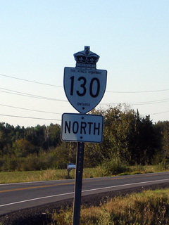
King's Highway
130 - www.OntHighways.com
Highway 130 is a short connector
highway that connects Highway 61 southwest of Thunder Bay to Highways 11&17

Old Style
King's Highway 130 Shield
|
|
Southern Terminus: Junction Highway
61, south of Thunder Bay.
Northern Terminus: At the Highway 11/17 junction west of
Thunder Bay
Length: 13.4 km
Multiplexes: None
Freeway: No.
AADT (2006):
Highest: 2,400, from Rosslyn Road northerly to Highway 11/17;
Lowest: 1,000, from Greenhouse Corners northerly to Rosslyn Road.
Road Info: Coming Soon! |
Communities and Major Intersections located Along Highway 130 from South to
North:
|
Proper Municipality Name |
Community Name |
Distance |
Intersection Name |
| Municipality of Oliver & Paipoogne |
----- |
0 km / 13.4 km |
King's Highway 61 |
| Municipality of Oliver & Paipoogne |
McCluskeys
Corners |
--- |
----- |
| Municipality of Oliver & Paipoogne |
Slate River
Valley |
--- |
----- |
| Municipality of Oliver & Paipoogne |
Twin City |
--- |
Rosslyn Road |
|
At Arthur Street: NB: Turn
Left towards Highway 11/17. SB. Turn right towards Twin City. |
| Municipality of Oliver & Paipoogne |
----- |
13.4km / 0km |
Arthur Street & Twin City Crossroads |
| Municipality of Oliver & Paipoogne |
----- |
XXXXX |
King's Highway 11/17
(Shabaqua Highway) |
|
Highway 130 ENDS |
<- Highway
129 www.OntHighways.com - Home
Highway 131 ->
Copyright (c) 2004-2011, AsphaltPlanet.ca
AsphaltPlanet@asphaltplanet.ca
Page last updated: March 20th, 2011
Page created: March 20th, 2011
