AsphaltPlanet.ca > OntHighways > Highway 69 > Images
< Hwy 67   Hwy 70 >

King's Highway 69 - www.OntHighways.com

Highway 69 forms the main link from Southern Ontario to the Greater Sudbury Region.  At the height of Highway 69's (modern) length, it ran from Highway 12 near Waubaushene to Highway 17 at Sudbury.  In recent years, Highway 69's length has been shrinking, as more and more of its routing is incorporated into other highways.  At the south end, as Highway 69 has been twinned, it has been re-designated as Highway 400.  Highway 69 now ends at the Musquash River bridge south of MacTier.  In the next few years, Highway 69 will likely be truncated at Parry Sound, as the section of  69 from MacTier to Hayes Corners will also likely be re-designated or decommissioned.  At the north end, in the mid-1990s Highway 17 replaced what was believed to be posted as Highway 69 on the Sudbury Southwest Bypass.


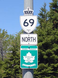
King's Highway 69 Shield


Southern Terminus:  As of Autumn 2003:  Highway 69 currently ends where the divided section of Highway 400 ends at the Musquash River Bridge near the Whata Mohawk Territory.

Northern Terminus:  The Highway 17 interchange on the Southern Bypass of Sudbury.

Length:  204.3 km (approx).

Multiplexes:  Highway 69 is currently multiplexed with Highway 400 for two small sections near Parry Sound.  The southern multiplex will likely be discontinued when the 'Whata Gap' is finally twinned, rendering Highway 400 four-laned from Toronto to Parry Sound.

Freeway: Highway 69 is a freeway where it runs concurrent with Highway 400 on the Parry Sound Bypass.

Trans-Canada Highway: Highway 69 makes up the Georgian Bay route for virtually all of its route.  The only portion of Highway 69 that is no longer part of the TCH, is the recently bypassed section between MacTier and Hayes Corners

AADT (2002):  Highest:  14,200 from Pioneer Road to the Highway 17 interchange;

                             Lowest:  5,050 from Highway 607 northerly to Highway 64.

Road Info:  Highway 69 is a very important highway, and is very well maintained for its entire length.  Calls have been made in recent years to twin Highway 69 to increase highway safety, though are very few notable design deficits on the route.   A great deal of the safety problems along Highway 69 come from poor driving behaviours.


Highway 69 information:


OntHighways.com  

Detailed Route information available below
Virtual Tour of Highway 69


TheKingsHighway.ca   History of Highway 69
Photographic History of Highway 69

Communities and Major Intersections along Highway 69 from South to North:

Proper Municipality Name Community Name Distance Intersection Road
Township of Georgian Bay -----   King's Highway 400-South Junction
Township of Georgian Bay -----   High Street (Muskoka Road 11)
Township of Georgian Bay Foot's Bay   Highway 169 (Muskoka Road 169)
Township of Seguin Lake Joseph   -----
Township of Seguin -----   Secondary Highway 612
Township of Seguin Gordon Bay   -----
Highway 141-West:  NB: Turn Right towards Parry Sound and Huntsville.  SB: Turn Left towards Toronto and Gravenhurst
Township of Seguin -----   King's Highway 141-West (To Highway 400)
Township of Seguin Hayes Corners   King's Highway 141-East
Township of Seguin Horseshoe Lake   -----

NB: Highway 69 rejoins Highway 400 at the south end of the Parry Sound Bypass.  Keep right at the trumpet interchange.  SB: To stay on Highway 69, exit at Exit #213 and follow the loop ramp.

Township of Seguin ----- (Hwy 400 Exit #213) King's Highway 400-South
Township of Seguin ----- (Hwy 400 Exit #214) Horseshoe Lake Road
Township of Seguin ----- (Hwy 400 Exit #217) Oastler Park Drive
Township of Seguin ----- (Hwy 400 Exit #220) Secondary Highway 518 & Hunter Drive
Municipality of McDougall Parry Sound Bypass (Hwy 400 Exit #224) Bowes Street & McDougal Drive
Divided highway ends approx 1km north of Bowes Street on the Parry Sound Bypass.  Highway 400 Ends at the end of Divided Highway
Town of Parry Sound Parry Sound Bypass   Parry Sound Drive (south jct)
Municipality of McDougall Parry Sound Bypass   King's Highway 124 & Parry Sound Drive (north jct)
Municipality of McDougall Nobel   -----
Township of Carling -----   Secondary Highway 559
Township of the Archipelago Pointe au Baril Station   Secondary Highway 644
Township of the Archipelago -----   Secondary Highway 529 (south jct)
Magnetawan IR 1 -----   Secondary Highway 529 (north jct)
District of Parry Sound -----   Secondary Highway 526
District of Parry Sound Still River   -----
Henvey Inlet IR 2 Bekanon   -----
District of Parry Sound Key River   -----
District of Parry Sound Cranberry   Secondary Highway 522
District of Parry Sound Bon Air   -----
Municipality of Killarney -----   Secondary Highway 607
Killarney - French River Boundary -----   King's Highway 64
District of Sudbury -----   Secondary Highway 637
District of Sudbury Estaire   -----
City of Greater Sudbury -----   Secondary Highway 537
City of Greater Sudbury -----   King's Highway 17
Highway 69 ENDS

www.OntHighways.com - Home


Copyright (c) 2004-2010, AsphaltPlanet.ca  AsphaltPlanet@asphaltplanet.ca

Page last updated:  January 3rd, 2005

Page created:  January 3rd, 2005